King Charles III England Coast Path in the west of England
Find out about Natural England's progress with improving coastal access.
Applies to England
Documents

Details
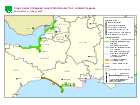
The map shows the stretches and provisional timings for improving coastal access in the west of England. Use the links in the table below to find out more information about each stretch.
| Stretch name | Progress |
|---|---|
| Aust to Brean Down - |
Stage |
| Aust |
Open to the public |
| Aust to Brean Down - Wain’s Hill, Clevedon to Beach Road car park (Sand Bay) | Stage 4: Determine |
| Aust to Brean Down - Beach Road car park (Sand Bay) to Brean Down Fort | Open to the public |
| Brean Down to Minehead | Open to the public |
| Lyme Regis to Rufus Castle | Stage 4: Determine |
| Rufus Castle on Portland to Lulworth Cove | Open to the public |
| Lulworth Cove to Kimmeridge Bay | Stage 2 and 3: Develop and Propose |
| Kimmeridge Bay to Highcliffe | Stage 4 and 5: Partially approved (not yet available for public use - work to establish the route is currently taking place on approved lengths) |
Last updated
-
Map and table updated to show a further section of the Aust to Brean Down stretch is now open to the public.
-
Map and table updated as approval for Chapter 6 of the Kimmeridge to Highcliffe stretch report has been quashed by High Court Order. This stretch reverts to stage 4/5, partially approved.
-
Map and table updated as another section of the Aust to Brean Down stretch (ABD1) has been approved.
-
Map and table updated to show that part of the Aust to Brean Down stretch is now open to the public.
-
Map and table updated to show that the Kimmeridge Bay to Highcliffe stretch has been approved.
-
Map and table updated to show that some sections of the Aust to Brean Down stretch have been approved.
-
Map and table updated to show that the Aust to Brean Down stretch is now at stage 4.
-
Kimmeridge Bay to Highcliffe is now at stage 4.
-
Replaced map with new version showing that the Brean Down to Minehead stretch is open to the public.
-
Updated map. Work has started on the Lulworth Cove to Highcliffe stretch.
-
First published.
Update history
2023-07-20 09:30
Map and table updated to show a further section of the Aust to Brean Down stretch is now open to the public.
2022-11-18 16:57
Map and table updated as approval for Chapter 6 of the Kimmeridge to Highcliffe stretch report has been quashed by High Court Order. This stretch reverts to stage 4/5, partially approved.
2022-06-23 09:00
Map and table updated as another section of the Aust to Brean Down stretch (ABD1) has been approved.
2022-06-16 10:30
Map and table updated to show that part of the Aust to Brean Down stretch is now open to the public.
2022-04-12 14:58
Map and table updated to show that the Kimmeridge Bay to Highcliffe stretch has been approved.