United Kingdom Single Issuing Authority (UKSIA)
The UKSIA manages UK domestic fishing vessel access to non-UK waters and foreign vessel access to UK waters.
The Marine Management Organisation (MMO) is acting as the UK Single Issuing Authority (UKSIA) to issue fishing vessel licences on behalf of the UK sea fish licensing authorities of England, Scotland, Wales and Northern Ireland to manage UK fishing vessel access to non-UK waters, and foreign vessel access to UK waters.
The UK is an independent coastal state and vessels from the EU and other coastal states wishing to access UK waters will require a fishing vessel licence issued by the UKSIA.
In addition to their UK licence, UK vessels require external waters licences to fish in waters outside of British Fishery Limits, including waters of the European Union and other coastal states such as Norway and the Faroe Islands, and in the waters of regional fisheries management organisations (RFMOs) to which the UK is a contracting party.
The UK fisheries authorities (Marine Scotland, the Department of Agriculture, Environment and Rural Affairs in Northern Ireland, Welsh Government and the Marine Management Organisation) remain responsible for the administration and management of UK vessel licensing within the UK EEZ.
UK Vessels
From 1 January 2021 vessels have been required to hold an external waters licence to fish outside of ‘British Fishery Limits’ (UK EEZ). Before applying for an external waters licence, please check that the area you intend to operate is outside of British Fishery Limits. View the map. Access for UK vessels to Crown Dependencies (CDs)’ territorial seas is through the relevant CDs who issue these fishing licences.
General Provisions for UK vessels
Applications for external waters licences must include a valid email address to which the licence will be issued and, for vessels 12m and over in length, an International Maritime Organization (IMO) number. Vessels will not be licensed without this information. If you have not notified your Sea Fish Licensing Authority or the SIA of a valid email address, or your email address has changed, you must send this to your administration port along with your vessel name, RSS number and PLN and we will update our records.
Vessels 12 metres and over in length must have an International Maritime Organization (IMO) number and permanently mark this in a visible place either on the ship’s hull or superstructure. If you do not already have an IMO number, you can apply for free at http://imonumbers.ihs.com. You must notify the UK SIA of your IMO number by emailing it to your administration port along with your vessel name, RSS number and PLN and we will update our records accordingly.
EU waters
Fishing by UK vessels in EU waters is subject to authorisation by the European Commission and requires a valid external licence issued by the UKSIA. The list of UK vessels has been published below with a copy of the licence conditions.
If your vessel is on the list but you have not received a licence please contact the UKSIA via the email address in the ‘Contact the SIA’ section on this page.
If you intend to operate outside of British Fishery Limits and wish to apply for an external waters licence, please complete the application form and submit to the SIA via the email address in the ‘Contact the SIA’ section on this page.

Access to Republic of Ireland 0-6nm
Northern Irish vessels are only permitted to access waters within 0 and 6 nautical miles of the territorial sea adjacent to the Republic of Ireland if expressly authorised at Part 1 section 3 of their UK external waters licence.
Norwegian waters 2023
Fisheries consultations between the United Kingdom and Norway for 2023 concluded on the 24 November 2022; you can find out more information here. If your vessel has access to fishing opportunities in Norwegian waters, you can now apply to the UK Single Issuing Authority (UKSIA) for an external waters licence to fish in 2023.
Please complete the application form at this link https://www.gov.uk/guidance/united-kingdom-single-issuing-authority-uksia and send it to the UKSIA at UKSIA@marinemanagement.org.uk.
You can apply at any time, but you cannot undertake activity in Norwegian waters until you are in receipt of a valid external waters licence issued by the UKSIA and your vessel appears in the list of authorised vessels below.
If you have any queries, please contact the UKSIA at UKSIA@marinemanagement.org.uk or call 02080265062.
Access to waters of Norway
Access to waters of Norway and the fishery protection zone around Svalbard have been agreed for 2023. Vessels with access to the relevant fishing opportunities can apply for an external waters licence by completing the application form below and submitting it to UKSIA@marinemanagement.org.uk. The UKSIA will verify applications with your fisheries administration and forward valid applications to the Norwegian Fisheries Directorate for approval. Upon receipt of approval the UKSIA will issue the external waters licence by email.
Access to waters of the Faroe Islands
Access to waters of the Faroe Islands has now been agreed for 2023. You can apply for an external waters licence by completing the application form which must include authorisation from your producer organisation at Section C to confirm that your vessel has access to the relevant fishing opportunities in Faroese waters.
Completed applications must be submitted to the UKSIA UKSIA@marinemanagement.org.uk who will verify your application with your fisheries administration and forward valid applications to the Faroese Ministry of Fisheries (Vørn) for approval. Upon receipt of approval the UKSIA will issue the external waters licence by email.
Please be aware that you must not fish in Faroe Island’s waters until you have received a valid licence.


UK fishing vessel licensing in RFMO waters 2023
If you intend to operate in the waters of a Regional Fisheries Management Organisation (RFMO) you will need a specific external waters licence in addition to your base domestic licence. If your vessel has access to fishing opportunities in NEAFC, ICCAT or IOTC waters you can now apply to the UK Single Issuing Authority (UKSIA) for an external waters licence to fish in 2023. Apply using the form below and submit to the SIA.

You can apply at any time but you cannot undertake activity in NEAFC, ICCAT or IOTC waters until you are in receipt of a valid external waters licence issued by the UKSIA and your vessel appears in the list of authorised vessels https://www.gov.uk/guidance/united-kingdom-single-issuing-authority-uksia#UK-vessellist.
The relevant RFMO conditions below apply to those vessels appearing on the UK vessel list for external waters below with a corresponding positive entry in the columns headed “NEAFC Waters Access” or “IOTC Waters Access” (only at this time). Your foreign vessel licence is subject to licence conditions. It is your responsibility to ensure you are aware of the licence conditions and any variations made to them.
If you have any queries please contact the UKSIA at UKSIA@marinemanagement.org.uk or call 02080265062 or visit the UKSIA website United Kingdom Single Issuing Authority (UKSIA) - GOV.UK (www.gov.uk).
General provisions for UK vessels
Until you are issued a valid licence for the waters in which you intend to operate you must not fish and all fishing gear must be lashed and stowed if transiting.
If you have not notified your Sea Fish Licensing Authority or the SIA of a valid email address, or your email address has changed, you must send this to your port of administration along with your vessel name, RSS number and PLN and we will update our records. In future, licences will only be issued by email.
Vessels 12 metres and over in length must have an International Maritime Organization (IMO) number and permanently mark this in a visible place either on the ship’s hull or superstructure. If you do not already have a IMO number you can apply for free at http://imonumbers.ihs.com. You must notify the UK SIA of your IMO number by emailing it to your port of administration along with your vessel name, RSS number and PLN and we will update our records accordingly.
You must not fish in third country waters until you have received a valid external waters licence issued by the UKSIA, and you must check that your vessel is on the UK vessel list for external waters published on this webpage with an indication in the appropriate third county waters column. If any of the details on your external waters licence are incorrect or for any other enquires relating to your external waters licence, please contact the UKSIA at UKSIA@marinemanagement.org.uk.
Foreign vessels
Since 1 January 2021 all foreign vessels are required to have a valid foreign vessel licence issued by the UKSIA to fish in UK waters including the UK EEZ, relevant areas of the UK 6-12nm zone, and in the 0-6nm zone around Northern Ireland. View the map
General Provisions for all foreign vessels
Until you are issued a valid licence for fishing in the UK EEZ or 6-12nm zone you must not fish and all fishing gear must be lashed and stowed if transiting. Enquiries regarding the licensing process for UK waters must be directed to your flag state fisheries authority.
Your foreign vessel licence is subject to licence conditions which are published on the UKSIA website. It is your responsibility to ensure you are aware of the licence conditions and any variations made to them, and applicable UK law, including customs rules, when operating in UK waters.
Norwegian vessels
Applications for Norwegian vessels to fish in UK waters are submitted by the Norwegian Directorate of Fisheries to the UKSIA. For details on how to apply you must contact your flag state fisheries authority directly. Where an application is approved, the UKSIA will issue a foreign vessel licence directly to the vessel owner by email. If any of the details in the licence you receive are incorrect, you should inform your flag state fisheries authority immediately.
A list of Norwegian vessels issued foreign vessel licences can be found in our approved Norwegian vessel section.
Your foreign vessel licence is subject to licence conditions. It is your responsibility to ensure you are aware of the licence conditions and any variations made to them. You can find the conditions in our approved Norwegian vessel section.
EU Vessels
Applications for EU vessels to fish in UK waters are submitted by the European Commission to the UKSIA on behalf of EU Member States.
Where an application is approved, the UKSIA will issue a foreign vessel licence directly to the vessel owner by email. If any of the details in the licence you receive are incorrect, you should inform your flag state fisheries authority immediately.
A list of vessels issued foreign vessel licences can be found in our approved EU vessel section.
Your foreign vessel licence is subject to licence conditions. It is your responsibility to ensure you are aware of the licence conditions and any variations made to them. You can find the conditions in our approved EU vessel section.
Faroese vessels
Applications for Faroese vessels to fish in UK waters are submitted by Vørn to the UKSIA. For details on how to apply you must contact your flag state fisheries authority directly. Where an application is approved, the UKSIA will issue a foreign vessel licence directly to the vessel owner by email. If any of the details in the licence you receive are incorrect, you should inform your flag state fisheries authority immediately.
A list of Faroese vessels issued foreign vessel licences can be found in our approved Faroese vessels section.
Your foreign vessel licence is subject to licence conditions. It is your responsibility to ensure you are aware of the licence conditions and any variations made to them. You can find the conditions in our approved Faroese vessels section.
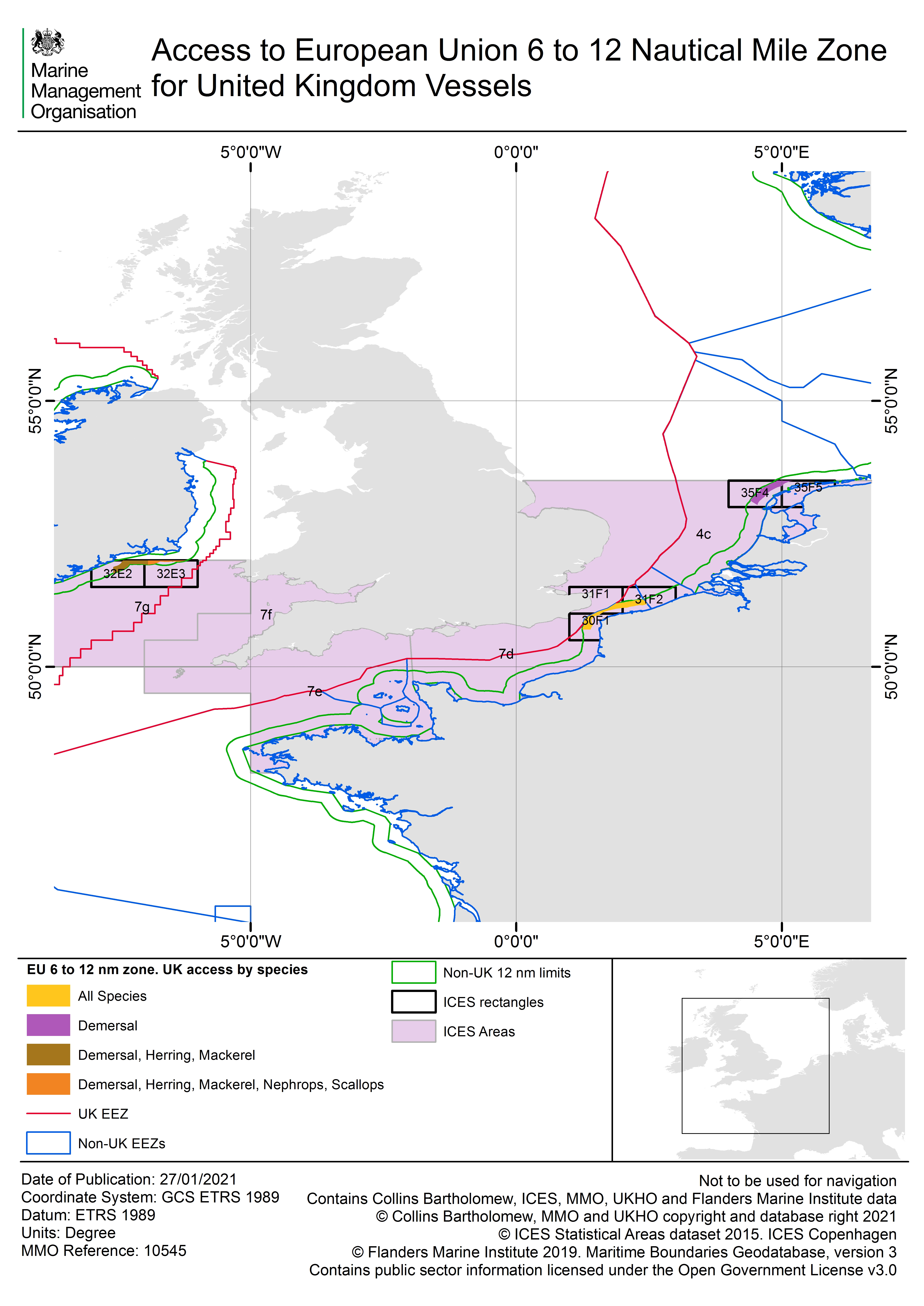
Access to UK and EU 6-12nm waters
Under Annex 38 to the UK-EU Trade and Cooperation Agreement (the ‘TCA’), during the adjustment period the UK and EU have rights of access for fishing in specific parts of each other’s waters between 6 and 12 nautical miles from baselines in ICES divisions 4c and 7d-g for qualifying vessels. Access is to fish in the zones and for the species specified in the table below. A qualifying vessel is one that fished for those species in the appropriate zone, in at least 4 of the 5 years between 2012 and 2016, or its direct replacement.
Access to UK waters for EU vessels
Evidence of qualification must include positional data showing fishing activity in the relevant UK 6-12nm zone with corresponding catch data recording catches of any of the permitted species for that zone (see table below). The catch data must be provided for the same date/time period as the positional data. This evidence must be provided for at least one day in each of four years out the five years between 2012 and 2016.
The UK will consider a range of evidence sources in its decision as to whether a vessel is a qualifying vessel:
Positional data
For vessels equipped with vessel monitoring systems (VMS) this type of data must be provided showing fishing activity within the relevant zone in all four years.
Vessels under-12 metres in overall length that were not equipped with VMS during the period but had an automatic identification system (AIS) installed must provide AIS data where VMS is not available.
Vessels under-12 metres which were not equipped with VMS or AIS throughout the period must provide chartplotter data clearly demonstrating the date/position/speed of the vessel, where VMS and AIS data are not available.
Where available, official sightings data at a position defined by latitude and longitude of fishing activity within the relevant zone of UK 6-12nm waters will also be considered.
All under-12m vessels must provide positional data (VMS, AIS, chartplotter or official sightings) for at least two out of the required four years. For the remaining years they must provide alternative evidence (see next section).
Alternative evidence
Vessels under-12 metres in overall length which do not have VMS, AIS or chartplotter or offical sightings data may provide alternative evidence of fishing activity within the relevant area, for up to two out of the required four years. This may be officially recognised scientific survey data such as Valpena data for French vessels (but only in relation to Valpena rectangles of which at least 50% is in the relevant zone of UK waters) or equally reliable and specific scientific survey data for vessels from other EU member States.
Again, this alternative evidence must correspond to the same date/time period as the catch data.
Where positional data is available which contradicts the alternative evidence supplied, that data will take precedence over the alternative evidence.
Catch data
Catch data must be provided from statutory returns including logbooks or, where appropriate, sales note data.
The catch data must record the permitted species for the relevant zone as indicated in the table below.
Catch data cannot be considered as evidence of qualifying activity on its own. For example, catch data recorded by ICES rectangle must be supported with positional data indicating that the catching activity was specifically carried out within that part of the ICES rectangle in the relevant zone of UK 6-12nm waters (see previous sections on positional data and alternative evidence).
Direct Replacements
Annex 38 of the TCA states that access to the relevant part of the UK and EU 6-12nm zone is granted for qualifying vessels, which includes direct replacements of the original qualifying vessels. The UK’s approach to licensing direct replacement vessels is based on ensuring that a replacement vessel is the same or similar to the original qualifying vessel it is replacing. This approach maintains the stability of the fisheries and also provides a limited but necessary degree of flexibility, while ensuring that no additional capacity is added to the fisheries beyond the level in place during the reference period 2012-2016.
The principles for the UK’s approach to direct replacements are outlined below:
- A global ceiling on vessel numbers, gross tonnage (GT) and engine power (kW) is established for each relevant member state of the EU, based on the qualifying vessels as at the end of the reference period (2012-2016). Replacements will not be authorised if they result in the ceiling being exceeded, even if they are within the limits on individual increases set out below.
- Replacements are made on a one for one basis.
- Replacements may only be made once a year, except in exceptional circumstances.
- A replacement vessel may only increase in capacity by up to 10% in kW and 20% in GT compared to the original qualifying vessel it is replacing.
- Any increase in kW or GT on replacement is always assessed by reference to the original qualifying vessel, not a previous replacement vessel.
- The replacement vessel must be of the same metier (gear type) as the original qualifying vessel. The metier groups are:
- Static/passive gear.
- Trawlers.
- Dredgers
- Demersal seine-netters.
There are two exceptions to principles four and six above:
a) Small vessels: where both the original qualifying vessel and the replacement vessel are under 12 metres in length and do not exceed 221kW, the vessels are not required to be of the same metier (gear type) and the restrictions on individual capacity increases do not apply.
b) Vessels replaced during the reference period or between 2017 and 2020 (i.e. before the TCA first applied): if the original qualifying vessel and the replacement vessel have a proven ownership link, or a proven direct capacity link stated in a “permis de mise en exploitation” (PME) for French vessels, a greater individual capacity increase of up to 40% in kW and 70% in GT is permitted. This is only permitted once and will not apply to any subsequent replacement of the qualifying vessel.
Licensing
Applications with supporting evidence for qualifying vessels are submitted to the UKSIA by the European Commission on behalf of a vessel’s flag member state.
The UK will assess applications and, in addition to the evidence provided, may use additional data sources including commercially available data in its evaluation. This includes AIS data which is commercially available.
EU vessel owners must direct enquiries regarding their applications and evidence to their national fisheries authority.
Table of permitted zones and species:
Vessels flying the flag of Belgium
| Sea area of United Kingdom waters between 6 and 12 nautical miles of the baselines in ICES areas 4c and 7d-g | Permitted Species* |
|---|---|
| An area between: (i) a line drawn due north from Cromer lighthouse and (ii) a line drawn due east from North Foreland lighthouse. | Demersal |
| An area between: (i) a line drawn due east from North Foreland lighthouse and (ii) a line drawn due south from Dungeness New lighthouse. | Herring Demersal |
| an area between: (i) a line drawn due south from Dungeness New lighthouse and (ii) a line drawn due south from Selsey Bill. | Demersal |
| an area between: (i) a line drawn south-east from Straight Point lighthouse and (ii) the northernmost boundary of ICES area 7g (Latitude 52°N) | Demersal |
| * “demersal” means all sea fish except salmon, migratory trout, mackerel, clupeoid fishes, sand eels, Norway pout, smelts, eels, great weevers, crustaceans and molluscs (other than squids). |
Vessels flying the flag of France
| Sea area of United Kingdom waters between 6 and 12 nautical miles of the baselines in ICES areas 4c and 7d-g | Permitted Species* |
|---|---|
| an area between: (i) a line drawn due east from Lowestoft lighthouse and (ii) longitude 2 degrees 56 minutes W; | All descriptions of sea fish |
| an area between: (i) longitude 2 degrees 56 minutes W and (ii) a line drawn due south from Eddystone lighthouse; | Demersal |
| an area between: (i) a line drawn due south from Eddystone lighthouse and (ii) a line drawn south-west from Longships lighthouse; | Demersal Lobster Crawfish scallops |
| an area between: (i) a line drawn south-west from Longships lighthouse and (ii) a line drawn north-west from Hartland Point lighthouse. | Demersal Lobster Crawfish |
| Such part of the area within 12 miles of the baselines adjacent to Lundy Island, but outside 6 miles from all baselines, as lies to the north and east of a line drawn north-west from Hartland Point lighthouse. | Demersal |
| Such part of the area within 12 miles, but outside 6 miles, from the baselines and between: (i) a line drawn north west from Hartland Point lighthouse and (ii) the northernmost boundary of ICES area 7g (Latitude 52°N) as lies outside 12 miles from the baselines adjacent to Lundy Island. | Demersal |
| * “demersal” means all sea fish except salmon, migratory trout, mackerel, clupeoid fishes, sand eels, Norway pout, smelts, eels, great weevers, crustaceans and molluscs (other than squids). |
Vessels flying the flag of Federal Republic of Germany
| Sea area of United Kingdom waters between 6 and 12 nautical miles of the baselines in ICES areas 4c and 7d-g | Permitted Species |
|---|---|
| an area between: an area between: (i) a line drawn due east from North Foreland lighthouse and (ii) a line drawn due south from Dungeness New lighthouse. | Herring |
Vessels flying the flag of the Netherlands
| Sea area of United Kingdom waters between 6 and 12 nautical miles of the baselines in ICES areas 4c and 7d-g | Permitted Species |
|---|---|
| an area between: (i) a line drawn due east from North Foreland lighthouse and (ii) a line drawn due south from Dungeness New lighthouse. | Herring |
Access to Northern Ireland 0-6nm
Republic of Ireland vessels are only permitted to access waters within 0 and 6 nautical miles of the territorial sea adjacent to Northern Ireland if expressly authorised at Part 1 section 3 of their UK foreign vessel licence.
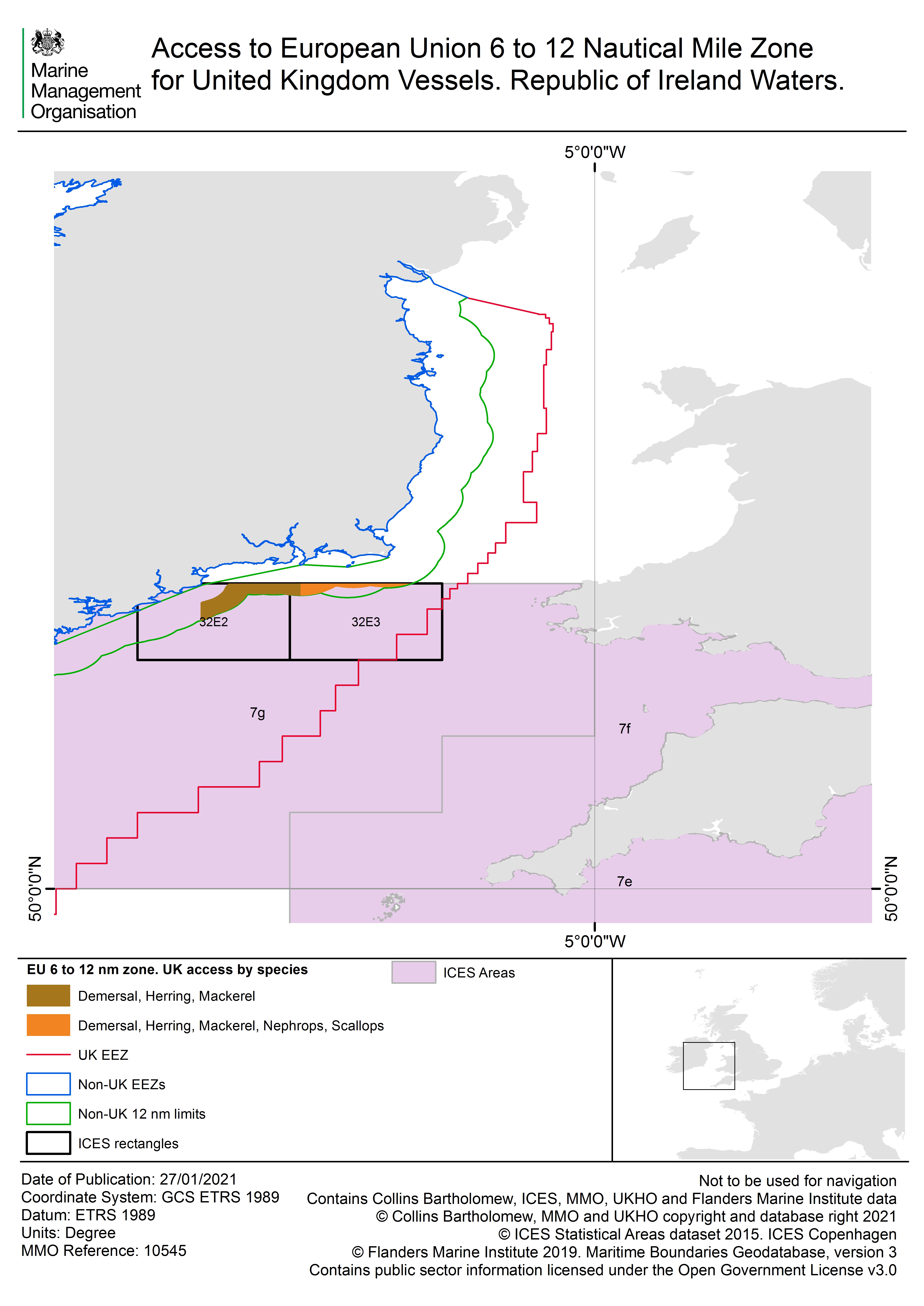
Access to EU waters for UK vessels
| Member State | European Union waters within 6 and 12 nautical miles from baselines of the coastal states of: | Permitted Species* |
|---|---|---|
| France | Belgian/French frontier to Cap d’Alprech west (50° 42 30” N — 1° 33’ 30” E) | All Species |
| Netherlands | Texel south point, west to the to the northernmost border of ICES 4c (line of latitude 53°30’N) | Demersal |
| Ireland | Mine Head south to Hook Point | Demersal Herring Mackerel |
| Ireland | Hook Point to the northernmost border of ICES 7g (line of latitude 52°N) | Demersal Herring Mackerel Nephrops Scallops |
| * “demersal” means all sea fish except salmon, migratory trout, mackerel, clupeoid fishes, sand eels, Norway pout, smelts, eels, great weevers, crustaceans and molluscs (other than squids). |
The following maps are available showing the areas of European Union waters within 6 and 12 nautical miles to which qualifying vessels have access:
EU Waters UK access EU Waters ROI UK Access
If you wish to apply for a licence to access EU waters within 6-12nm please complete the application form below and submit it to the uksia@marinemanagement.org.uk with your supporting evidence.
Contact the SIA
You can reach the SIA via telephone on 0208 026 5062 or email UKSIA@marinemanagement.org.uk with your name, telephone number, vessel name and PLN number and a brief outline of your enquiry and a member of the team will call you back as soon as possible.
Approved UK Vessels
External waters licences are issued by email for access to EU, Norwegian, Faroe Islands and Regional Fisheries Management Organisation waters. Before fishing in any external waters, you must check that you are on the 2023 list of approved vessels and in receipt of your external waters licence.
If your vessel is on the list but you have not received your licence by email, contact the UKSIA immediately. If your vessel does not appear on this list, or you wish to apply for an external waters licence, please contact the SIA using the details above.
It is the responsibility of the licence holder and vessel master to ensure they are familiar with the conditions set out in your fishing vessel licence. Please ensure that you do not fish outside of the times permitted by your licence. Validity dates can be found at part 1 section 3 of the licence issued to you.


Approved Norwegian Vessels
Below is the list of Norwegian vessels for which a foreign vessel licence has been issued for UK waters in respect of access to the UK EEZ (12-200nm limit), with validity as indicated in the relevant columns. This list is also maintained and published on behalf of Scottish Ministers for the purposes of section 44 of the Fisheries Act 2020.
The foreign vessel licence conditions for Norwegian vessels and most recent notification of variation that applies to these licences are also available below.
Approved EU Vessels
UK Foreign Vessel Licences for access to UK waters in 2023 have been issued by email to EU vessel owners and, where notified, copied to vessel operators for the vessels in the 2023 – EU Vessel list for UK waters below. Before fishing in UK waters you must check that you are on the list of approved vessels and in receipt of your external waters licence. You must contact your flag state fisheries authority if you have not received your licence or your vessel is not on the 2023 list.
Below is the list of EU vessels for which a foreign vessel licence has been issued for UK waters in respect of access to UK EEZ (12-200nm limit), UK 6-12nm (ICES 4c, 7d-g) and Northern Ireland 0-6nm under the Voisinage arrangements, with validity as indicated in the relevant columns. This list is also maintained and published on behalf of Scottish Ministers for the purposes of section 44 of the Fisheries Act 2020. The Foreign vessel licence conditions and most recent notification of variation that applies to these licences are also available below.”


Approved Faroese Vessels
Below is the list of Faroese vessels for which a foreign vessel licence has been issued for UK waters in respect of access to the UK EEZ (12-200nm limit), with validity as indicated in the relevant columns.
This list is also maintained and published on behalf of Scottish Ministers for the purposes of section 44 of the Fisheries Act 2020. The Foreign vessel licence conditions and most recent notification of variation that applies to these licences are also available below

Crown Dependencies
Access of EU vessels to the territorial sea around the Crown Dependencies
The Crown Dependencies are the Bailiwick of Guernsey (Guernsey, Alderney and Sark) (“Guernsey”), the Bailiwick of Jersey (“Jersey”) and the Isle of Man.
Under article 502 of the Trade and Cooperation Agreement (TCA) between the United Kingdom and the European Union, the EU and the UK on behalf of each of Guernsey, Jersey and the Isle of Man, have granted each other access to certain parts of their territorial seas.
This access reflects the actual extent and nature of fishing activity that it can be demonstrated was carried out by qualifying vessels from 1 February 2017 to 31 January 2020 (the reference period), under the treaty arrangements which were then in force (the former London Fisheries Convention and the former Granville Bay Agreement). A qualifying EU vessel is one which can demonstrate that it fished in the territorial sea around the relevant Crown Dependency on at least 11 days in any of the 12-month periods ending on 31 January 2018, 31 January 2019 or 31 January 2020.
Implementation by Guernsey and Jersey
Guernsey implemented access to relevant waters in two stages. Following initial interim arrangements during 2021, in most cases licences to fish in those waters took effect from 1st February 2022. Then, from 1st February 2023, conditions were added to licences to reflect the limits set by the TCA on the extent and nature of fishing.
The arrangements Guernsey have put in place to implement this access can be found on their government’s website at https://www.gov.gg/fishing. They include arrangements for licensing replacement vessels.
Similarly, Jersey also implemented access to relevant waters in two stages. In most cases licences were issued to EU vessels in 2021. Then, from 1st February 2023, further conditions were added to licences to reflect the limits set by the TCA on the extent and nature of fishing.
The arrangements Jersey have put in place to implement this access can be found on their government’s website at Fishing boat licensing (gov.je).They include arrangements for licensing replacement vessels.
Licensing of EU vessels by the Crown Dependencies
The Crown Dependencies are responsible for authorisation and licensing of fishing vessels within their waters. Applications for EU vessels to fish in the waters around a Crown Dependency are submitted by the European Commission to the UK Single Issuing Authority (SIA) on behalf of EU Member States. The SIA operates as a single point of contact between the Crown Dependencies and the European Commission for the purposes of exchanging information for licensing and authorisations.
Applications are forwarded to the relevant Crown Dependency and where an application is approved, that Crown Dependency will issue a licence directly to the owner of the relevant EU vessel by email. The Crown Dependencies may charge a fee for fishing vessel licences. If any of the details in the licence that you receive are incorrect, you should inform your flag State fisheries authority immediately.
EU vessels licensed by Guernsey
The EU vessels listed below are licensed by Guernsey to fish in the relevant waters around Guernsey (in line with the TCA).
These licences are subject to licence conditions. The template conditions can be found on the Government of Guernsey’s website. Additional access conditions may also be included in the licences of specific vessels in order to reflect the TCA.
It is your responsibility to ensure that you are aware of the licence conditions and any variations made to them.
Further details and applicable legislation are available at https://www.gov.gg/fishing.
EU vessels licensed by Jersey
The EU vessels listed below are licensed by Jersey to fish in the relevant waters around Jersey (in line with the TCA).
These licences are subject to licence conditions. The template conditions can be found on the Government of Jersey website These conditions apply equally to full and temporary licences. Additional access conditions may also be included in the licences of specific vessels in order to reflect the TCA.
It is your responsibility to ensure you are aware of the licence conditions and any variations made to them.
The EU vessels on the following list are authorised to conduct fishing activities in Jersey waters under a temporary licence.
Isle of Man
Information on foreign vessel licensing in Isle of Man territorial waters can be found here. To date the European Commission has not put forward any vessels for access to Isle of Man waters under the TCA and therefore there are no specific arrangements in place for access. The arrangements put in place by Guernsey and Jersey do not prejudice the right of the Isle of Man make their own arrangements for implementation in the future.
Devolved Administrations
The UK fisheries authorities (Marine Scotland, the Department of Agriculture, Environment and Rural Affairs in Northern Ireland, Welsh Government and the Marine Management Organisation) remain responsible for the administration and management of UK vessel licensing within the UK EEZ.
Marine Management Organisation
Website: https://www.gov.uk/guidance/understand-your-fishing-vessel-licence Phone: 0300 123 1032
Marine Scotland
Website: https://www.gov.scot/policies/marine-and-fisheries-licensing Phone: 0300 244 4000
Department of Agriculture, Environment and Rural Affairs (DAERA)
Website: https://www.daera-ni.gov.uk/topics/fisheries/fishing-vessel-licensing
Welsh Government
Website: https://gov.wales/sea-fisheries
Regional fisheries management organisations (RFMO)
- North East Atlantic Fisheries Commission (NEAFC)
- Northwest Atlantic Fisheries Organization (NAFO)
- International Commission for the Conservation of Atlantic Tunas (ICCAT)
Compliance and legislation

At 11pm on 31 December 2020 the majority of European Union fisheries legislation was retained as UK law and continues to apply to UK fishing vessels and foreign vessels fishing in UK waters (where appropriate). At the same time relevant national fisheries legislation also became applicable to foreign vessels. Fisheries is a devolved matter in the UK and alongside national legislation and retained EU law there are specific regulations that apply in English, Scottish, Welsh and Northern Irish waters. Links to the legislation are below:
The official website for all UK regulations is https://www.legislation.gov.uk/
The Marine Management Organisation (MMO) publishes a non-exhaustive list of fisheries legislation called the ‘Blue Book’.
https://www.gov.uk/government/publications/fishing-regulations-the-blue-book
Guidance and legislation applicable in Scottish waters can be found at the following links:
https://www.gov.scot/policies/marine-and-fisheries-compliance/
https://www.gov.scot/publications/marine-and-fisheries-compliance-legislation/
Northern Ireland legislation applicable to non-UK vessels fishing in NI waters https://www.daera-ni.gov.uk/publications/northern-ireland-legislation-applicable-non-uk-vessels-fishing-ni-waters
Last updated
-
UK & EU list update
-
attachments updated
-
Attachments updated.
-
Attachments updated
-
EU update
-
UK vessel list update
-
Small amend
-
Attachements updated.
-
Attachments updated.
-
Attachments updated
-
Attachments updated.
-
Attachments updated.
-
Attachments added.
-
Attachment updated.
-
Attachments updated.
-
Attachments updated.
-
Attachments updated.
-
Attachments updated
-
Attachments updated.
-
Attachments updated.
-
Attachments updated.
-
Attachment updated.
-
Attachments updated.
-
UK Foreign Vessel Licence (NOR Vessels) (Mackerel) Variation 2 Conditions 08 September 2023 - update
-
Attachments updated.
-
EU Vessel list update
-
UK Foreign Vessel Licence (NOR Vessels) (Mackerel) Variation 1 Conditions 07 September 2023 update
-
Attachments updated.
-
Attachment updated.
-
Attachments updated
-
Attachments updated.
-
UK Foreign Vessel Licence (NOR Vessels - MAC) Conditions 2023 attachment added.
-
Attachments updated.
-
Attachments updated.
-
Attachments updated.
-
Attachments updated.
-
Update 25/08
-
Vessel list update
-
Attachments updated.
-
Attachments updated.
-
Attachments updated.
-
Attachments updated.
-
Attachments updated.
-
Attachments updated.
-
Attachments updated
-
Attached spreadsheets updated.
-
Attachments updated
-
Updated vessel list
-
Attachments updated.
-
Updated attachments
-
Attached spreadsheets updated.
-
Attachment updated
-
UK Vessel List for External Waters update 31/07
-
Attachment updated.
-
Attachments updated
-
Attached spreadsheets updated
-
Updated spreadsheet attachments
-
Attached spreadsheets updated
-
Updated spreadsheet.
-
Editing outdated info.
-
Spreadsheets updated
-
Spreadsheets updated
-
Updated attachments.
-
Spreadsheets updated
-
Attachments updated
-
Attachment updated
-
Updated spreadsheet
-
Variation update
-
Spreadsheets updated
-
Updated spreadsheet
-
Spreadsheets updated
-
Updated spreadsheets
-
Attachment updated
-
Attachments updated
-
Attachments updated
-
2023 - UK Vessel List for External Waters - update
-
Jersey vessel list update
-
Attachments updated.
-
Attachments updated
-
UK Foreign Vessel Licence (EU Vessels) Var 3 20230701 Conditions - added
-
Attachment updated
-
Attachments updated.
-
Attachments updated.
-
Attachment updated.
-
EU Vessel list update
-
Attachments updated
-
Attachments updated: EU vessel list for UK waters NOR vessel list for UK waters
-
Updated attachment: UK Vessel List for External Waters 20230615
-
UK Foreign Vessel Licence (EU) (ICCAT) (ALB) Conditions 2023 - update
-
Attachments updated: UK Vessel list for External Waters 20230615 FRO Vessel List for UK Waters 20230615
-
UK Foreign Vessel Licence (EU Vessels) (ICCAT) (ALB) 2023 - updated
-
The following attachments added: FRO Vessel List for UK Waters - 14/06/2023 UK Vessel List for External Waters - 14/06/2023 EU Vessel List for UK Waters - 14/06/2023
-
EU Vessel List for UK Waters and UK Vessel List for External Waters - updated.
-
Two new attachments added UK Foreign Vessel Licence (EU) (ICCAT) (ALB) Conditions 2023 and UK Vessel Licence – External Waters (ICCAT) (ALB) Conditions 2023
-
Attachments updated - UK Vessel List for External Water and EU Vessel List for UK Water
-
Updated attachments: UK Vessel list for external waters, EU Vessels for Jersey Waters
-
UK vessel list for External waters and EU vessel list for Jersey waters updated.
-
07 June 2023 update.
-
UK and Eu vessel lists 2023 updated.
-
05 June 2023 update.
-
Vessel lists updated
-
01 June 2023 update.
-
Vessel lists updated
-
EU vessel list for UK waters 30 May 2023 added
-
EU vessel list for UK waters updated
-
25 May 2023 update.
-
UK and NOR vessel lists and Faroese licence conditions updated.
-
23 May 2023 update.
-
22 May 2023 update.
-
UK and EU vessels lists updated.
-
UK and EU vessel lists updated.
-
UK and EU vessels lists 2023 updated
-
EU and UK vessels lists updated.
-
UK and EU 2023 Vessel lists updated.
-
EU vessels for Guernsey Waters Access - updated
-
Vessel list update 12/05
-
Variation update 11/05
-
2023 - UK Vessel List for External Waters - updated
-
UK & EU vessel update
-
UK Vessel List for External Waters - update
-
2023 - UK Vessel List for External Waters
-
Vessel list update - 03/05
-
EU Vessel List for UK Waters - update
-
Vessel list update - 28/04
-
UK Vessel List for External Waters - updated
-
26 April 2023 update.
-
26 April 2023 update.
-
UK & EU vessel list update
-
EU & UK update
-
EU vessel list update 20.04
-
EU & NOR vessel list updates
-
Vessel list update
-
13 April 2023 update.
-
UK and EU vessel list update
-
Faroes Island update
-
UK & EU vessel list updates
-
EU Vessel List for UK Waters - update
-
Vessel list updates 04/04
-
UK Vessel list updates 03/04
-
EU vessel list update
-
UK & EU vessel list updates
-
Variation updates
-
UK & EU updates 29/03
-
Norway and EU update
-
27 March 2023 update.
-
24 March 2023 update.
-
SIA update
-
Norway Vessel List for UK waters - update
-
UK & EU vessel list update
-
UK Vessel and EU Vessel list update
-
UK & EU vessel list update
-
UK, EU and NOR Vessel list updates for 16/03
-
2023 - UK Vessel List for External Waters - updated
-
2023 - UK Vessel List for External Waters - updated
-
2023 - EU Vessel List for Jersey Waters Access - Update
-
2023 - UK Vessel List for External Waters (Update)
-
Vessel list update
-
Vessel list updates
-
UK & EU update
-
UK Vessel List for External Water - update
-
Update 02 March 2023.
-
UK vessel list update
-
UK & EU update
-
UK Vessel List for External Waters - update
-
UK Vessel List for External Water - update
-
UK & NOR vessel list update
-
UK Vessel List for External Waters - update
-
UK & EU vessel list updates
-
UK & EU Vessel list update
-
UK and EU Vessel list update
-
EU and UK vessel list update
-
UK & EU vessel list update
-
Update 13 February 2023.
-
UK Vessel List for External Waters - update
-
EU Vessel List for UK Waters - update
-
UK & EU updates
-
UK, EU and NOR updates
-
UK Foreign Vessel Licence (EU Vessels) Variation 09-02-2023 Conditions - added
-
2023 - UK Vessel List for External Waters - updates
-
Norway & UK Vessel List for External Waters update
-
Updated
-
UK, EU and Norway vessel list
-
UK Vessel list update
-
EU Vessel List of TCA licences for Guernsey Waters Access from 1 February 2022 - update
-
UK & EU Vessel list update
-
UK, EU and NOR update
-
Small updates
-
UK & EU and Norway update
-
UK, EU and Norway vessel list updates
-
UK Vessel List for External Waters & EU Vessel List for UK Waters update
-
EU & UK list update
-
Update 20 January 2023.
-
Attachment 'UK Foreign Vessel Licence EU Vessels Conditions 2023' updated.
-
2023 - UK Vessel List for External Water - update
-
SIA amend
-
UK Vessel List for EU Waters & EU Vessel List for UK Waters - update
-
Updated
-
Update: UK Foreign Vessel Licence (NOR Vessels) Variation 1 Conditions| 13 January 2023
-
2023 - UK Vessel List for EU Waters - update
-
SIA amends
-
UK and EU Vessel list update
-
EU & Norway vessel list updates
-
Approved EU Vessel list for UK waters update
-
UK fishing vessel licensing in EU waters 2023 - amend
-
Update 30 December 2022
-
Conditions update 2023
-
UK & EU vessel list update 2023
-
Vessel list update 22/12/22
-
Updated to include revised vessels lists - EU Vessels for UK waters 2023, Norwegian vessels for UK waters 2023 and UK vessels for Norwegian waters 2023.
-
UK vessel list for EU waters 2023 updated.
-
2023 update
-
Norway Vessel List for UK waters - update 16/12
-
EU & UK update
-
Application for External Waters Licence Regional Fisheries Management Organisation (RFMO - update
-
As of 00:01 hours on 10 December 2022 UK vessels will no longer be authorised to fish in in the Faroes Exclusive Economic Zone EEZ
-
Update 02/12
-
EU vessel list for UK waters - update 30/11
-
Application for External Waters Licence Norway & Svalbard - update
-
EU & UK update 29/11
-
EU update
-
UK & EU vessel list update
-
EU vessel list for UK waters - update
-
EU & UK update
-
EU vessel list for UK waters 21/11 update
-
EU vessel list for UK waters - updated
-
EU & UK Vessel list update
-
EU vessel list for UK waters - update!
-
EU update
-
EU update
-
EU update
-
UK Vessel List for External Waters - update
-
Eu update
-
UK Vessel List for External Waters - update
-
EU & NOR update
-
UK & EU vessel list update
-
EU vessel list for UK waters - update
-
UK Vessel List for External Waters - update!
-
UK Vessel List for External Waters - update EU Vessel List for Jersey Waters Access - update
-
EU & UK vessel update
-
EU, UK and Norway vessel list update
-
EU & UK Vessel list update
-
UK Vessel List for External Waters - update
-
EU & UK Vessel list update
-
EU vessel list for UK waters - update
-
EU vessel list for UK waters - Update
-
EU and UK Vessel list update
-
2022 UK Vessel List for External Waters - update
-
EU Vessel list update & updated conditions
-
EU vessel list for UK waters - Update
-
EU, UK and Norway Vessel list updates
-
EU vessel list for UK waters updated.
-
EU vessel list for UK waters - update
-
UK Vessel List
-
EU, UK, Norway and Faroese vessel list update
-
EU & UK Vessel List update
-
UK, EU and Norway vessel list update
-
UK Vessel List for External Waters UPDATE
-
UK Vessel List for External Waters - update
-
EU vessel list for UK waters and UK vessel list for external waters updated.
-
UK vessel list for external waters and EU vessel list for UK waters have been updated.
-
UK vessel list for external waters updated
-
EU vessel list for UK waters and UK vessel list for external waters updated.
-
EU vessel lists for Jersey and UK waters updated.
-
EU vessel list for UK waters updated.
-
EU & UK Vessel list update
-
EU vessel list for UK water & EU Vessel List for Jersey Waters Acces
-
EU vessel list for UK waters - update
-
EU vessel list for UK waters - update
-
UK Foreign Vessel Licence Variation update
-
EU vessel list for UK waters updated.
-
14 September update
-
EU & NOR update
-
2022 - EU Vessel List for Jersey Waters Access - update
-
EU & UK Vessel list update
-
Vessel list update
-
EU vessel list for UK waters - update
-
EU & UK vessel list update
-
UK & EU Vessel list update
-
Vessel list update for UK and EU
-
UK Vessel List for External Waters update
-
UK Vessel list for External Waters updated
-
EU Vessel list update
-
EU Vessel List for Jersey Waters Access - Update
-
UK Vessel list update
-
26 August update
-
25 August 2022 update
-
EU & UK update
-
EU & UK update
-
UK Vessel update
-
UK Vessel list update
-
UK Vessel list update
-
EU update
-
UK Vessel update
-
UK & NOR vessel list update
-
EU update
-
UK & NOR Update
-
UK Vessel update
-
EU & NOR vessel list update
-
UK Foreign Vessel Licence (EU Vessels) Conditions (Variations) - update
-
UK vessel list update
-
EU update
-
UK, FRO and EU vessel update
-
UK update
-
UK update
-
EU vessel list
-
EU Vessel list update
-
EU Vessel List update
-
Vessel list update
-
Eu vessel list update
-
UK & EU Vessel list
-
Vessel list update
-
Vessel List update
-
UK Vessel update
-
UK vessel list update
-
EU & UK update
-
EU & UK update
-
Jersey list update
-
EU and Norway Vessel List update
-
Jersey EU Vessel List
-
EU Vessel List
-
EU & UK vessel list update
-
EU vessel list update
-
UK, EU, FRO vessel list updates
-
EU & NOR update
-
Update UK & EU
-
UK & EU list update
-
EU update
-
Norway and EU vessels lists for UK waters updated
-
EU vessel list for UK waters updated
-
Vessels lists updated as at June 8 2022
-
UK Vessel List Update
-
FRO update
-
UK & EU vessel lists ypdated
-
uk and faroes vessel lists updated
-
EU & UK vessel lists updated
-
NOR & EU vessel lists updated
-
Page updated with LICENCE TO FISH IN UNITED KINGDOM WATERS – FAROE ISLANDS VESSEL
-
EU UK & NOR vessel lists updated
-
UK & FRO updates
-
Page updated with Faroese vessel list
-
Page updated with UK, EU & Norway vessel lists
-
EU and Norway update
-
UK Vessel List
-
EU & UK vessel lists updated
-
Norway Vessel List update for UK Waters
-
EU Update
-
EU vessel list updated
-
EU UK & NOR vessel lists updated
-
UK & EU vessel lists updated
-
page updated with UK Foreign Vessel Licence Conditions (2022)
-
EU & UK vessel lists updated
-
EU Vessel List for Jersey Waters Access – Temporary Licence - updated
-
EU vessel list updated
-
UK & EU vessel lists updated
-
EU & UK lists updated
-
UK and EU vessel lists updated
-
EU & UK vessel lists updated
-
EU & UK vessel lists updated
-
UK update
-
EU & UK Update
-
UK & EU update
-
UK Vessel Update
-
EU Update
-
EU & UK lists updated
-
Lic Conditions
-
EU Vessel list updated
-
UK list for external waters updated
-
Norway and UK vessel lists updated
-
UK Foreign vessel licence (EU Vessels) Conditions 2022 document updated
-
EU vessel list updated
-
Spreadsheets updated
-
UK Vessel list update
-
UK Vessel list update
-
UK Vessel List
-
Updates 09/03
-
EU & UK Vessel lists
-
EU & UK vessel lists updated
-
Vessel lists updated
-
External & Jersey access
-
UK & EU
-
UK & NOR Update
-
UK & EU List
-
EU Vessel list for UK Water
-
NOR updates
-
RFMO update
-
SIA Norway form
-
UK Vessel List update
-
UK Vessel List update
-
EU list for UK Waters
-
EU vessel list updated
-
UK list updated
-
Page updated with EU Vessel List of TCA licences for Guernsey Waters Access
-
UK & EU vessel lists updated
-
EU & UK lists updated
-
UK & Norway vessel list
-
UK list updated
-
Uk and Norway lists updated
-
EU & UK vessel lists updated
-
UK & Norway lists updated
-
Jersey and Guernsey updates
-
UK and EU vessel lists updated
-
spreadsheets updated for EU & UK
-
EU List update
-
UK List update
-
EU vessel list updated
-
EU & UK lists updated
-
Vessel lists updated
-
EU & UK lists updated
-
EU & UK vessel lists updated
-
EU list updated
-
Norway Vessel List
-
UK VL update
-
EU & UK updates
-
UK & EU sheets updated
-
EU & UK update
-
EU List
-
10 update
-
EU & UK lists
-
Vessel list update
-
EU Vessel list update
-
2022 update
-
Updates to Guernsey licences
-
EU vessel list for Jersey waters updated
-
2022 UK vessel list for EU waters published
-
2022 Vessel list
-
Details updated following the agreement for access to waters of Norway and the fishery protection zone around Svalbard.
-
EU vessel list update
-
UK vessel update
-
UK Vessel update
-
EU vessel list for UK waters updated
-
EU and UK vessel lists updated
-
UK vessel update
-
EU Vessel list update
-
EU update
-
UK Vessel
-
EU updates
-
UK Vessel list
-
EU & UK Vessel update
-
EU Vessel list update
-
EU Vessel
-
EU & UK vessel list update
-
Jersey update
-
Jersey update
-
EU Vessel list
-
EU List update
-
Page updated with vessel list - Bailiwick of Guernsey licences
-
UK & EU updates
-
UK & EU vessel updates
-
EU vessel list update
-
EU Vessel updated (2nd Edition)
-
EU List updated
-
UK Vessel list update
-
EU vessel list for UK waters
-
EU & UK vessel update
-
EU water
-
Jersey update
-
EU Vessel list update
-
UK Vessel list 5pm update
-
UK Vessel update
-
Updates
-
UK & EU list update
-
EU Vessel List Update
-
UK Vessel List
-
UK & EU list update
-
November privacy notice
-
UK Vessel list update
-
UK Vessel List
-
UK vessel list update
-
Vessel lists for Jersey waters updated.
-
UK Vessel List
-
Guernsey update
-
UK Vessel list update
-
EU Vessel update
-
UK Vessel list
-
EU Vessel List
-
Privacy notice update
-
EU list update
-
EU Vessel list update
-
Jersey List update
-
EU Vessel list
-
EU vessel list for UK waters update
-
Guernsey update
-
Form updates
-
EU vessel list for UK waters updated
-
EU vessel list for UK waters updated
-
EU Vessel update
-
UK Vessel list update
-
UK Vessel list update
-
UK Vessel list update
-
variation update
-
Gurnsey update
-
UK update
-
6-13mm update
-
EU update
-
UK Vessel update
-
EU vessel conditions update
-
EU Vessel list update
-
EU update
-
EU update
-
SIA Application to Fish In European Union update
-
EU & UK update
-
EU Vessel list update
-
UK and EU vessels lists updated
-
EU list update
-
EU & UK update
-
Jersey list update
-
UK vessel update
-
UK waters
-
UK Vessel List updated!
-
EU Vessel List update
-
EU and UK update
-
EU Vessel list update for UK waters
-
conditions UK update
-
variation update
-
Conditions update
-
External update
-
EU update
-
EU update
-
Vessel List update
-
Guernsey update
-
UK List
-
UK Vessel update
-
UK List
-
EU Vessel List
-
UK list for externals updated
-
EU vessel list
-
EU 6-12nm waters update
-
UK & EU Vessel Lists
-
European Waters form
-
EU Vessel Update
-
EU list update!
-
UK Vessel List
-
Eu list update
-
EU vessel list update
-
Text update
-
EU Vessel List update
-
UK Vessel List update
-
EU Vessel List update
-
EU Vessel List
-
CD update
-
EU vessel list update
-
Update RFMO
-
EU Vessel List
-
EU Vessel List
-
EU list update
-
UK Vessel List
-
EU list for UK waters
-
UK Vessel list updated
-
EU-UK waters vessel list updated.
-
EU-UK and UK-External waters vessel lists updated.
-
page updated with UK Vessel List for External Waters
-
Page updated with EU vessel list for UK waters
-
UK Vessel List
-
EU Vessel List updated
-
UK vessel list update
-
EU Vessel List update
-
Vessel List updated
-
UK Vessel List
-
EU List
-
Guernsey Water List updated
-
UK Vessel list update
-
UK< EU and Gurnsey list
-
EU Vessel List
-
UK list
-
EU Vessel list updated
-
UK Vessel List
-
UK List
-
EU Vessel List
-
Jersey List
-
External Waters licence (EU) Conditions updated
-
Jersey update
-
Jersey update
-
EU vessel list
-
UK Vessel List update
-
EU List update
-
EU update
-
Update - UK List
-
Jersey update
-
EU List
-
UK List Update
-
UK & EU Lists updated
-
UK list updated
-
EU list updated
-
UK & EU list update
-
UK list updated
-
EU & UK list update
-
EU list done
-
UK list updated
-
UK list update
-
UK update
-
EU & UK list update
-
UK List
-
EU List update
-
EU List
-
EU List
-
Updated conditions
-
Document update
-
EU list update
-
Vessel List
-
Document update
-
EU list update
-
UK Vessel list
-
Updated Guernsey text
-
EU list update
-
EU List update
-
22nd Update UK Vessels for EU Waters
-
UK Water list updated
-
UK list updated
-
EU List update
-
EU & UK List update
-
UK Vessel update 12/03
-
11/03 updates
-
Text amends
-
UK Vessels
-
UK Vessel List Updated
-
EU Vessel List update
-
EU Vessel List
-
EU Vessel List
-
EU Vessel List Update
-
Uk Vessels in EU Wates list updated
-
SIA update 26/02
-
EU and UK Water List Update 25/02
-
Variations added for UK temporary foreign vessel licence (EU vessels) and UK foreign vessel licence (EU vessels) Conditions
-
UK vessel list for external waters updated and NEAFC vessel licence (UK vessels) conditions added.
-
EU vessel list for UK waters updated
-
Water Lists
-
COntent update
-
EU & UK water lists updated 17/02
-
EU Vessel List
-
EU Vessel List Updated 15/2
-
EU & UK Waters updated
-
Compliance and legislation section added
-
EU Vessel List
-
Uk vessel list for Eu waters
-
EU Vessel list - update
-
RFMO Waters title added
-
If you intend to operate in the waters of an Regional Fisheries Management Organisation RFMO you will need a specific external waters licence in addition to your base domestic licence. Apply using the form below and submit to the SIA. - Added
-
EU Vessel list for UK Waters - Updated 05/02
-
UK vessel list for EU waters - updated
-
Updated EU Vessel List
-
Docs updated
-
Updated
-
Docs Updated
-
Updated species list for access to Irish waters for UK waters
-
Page amended to reflect licensing arrangements for 6-12nm zones.
-
Eu Vessel List and Guernsey Access List updated.
-
EU Vessel list for UK waters updated
-
UK Vessel list for EU waters - update
-
EU Vessel list for UK Waters
-
EU Vessel list for UK waters - Updated
-
UK Vessel list - update
-
SIA Application update V3
-
EU Vessl list for UK Waters updated
-
updated application form
-
EU vessels for UK waters update
-
EU waters - update
-
Updated EU vessel list for UK Waters
-
list of UK vessels allowed to fish in EU waters updated
-
UK vessels list for EU waters updated
-
Conditions updated
-
Updated UK vessel list for EU waters
-
EU vessel list for UK waters update
-
Jersey & IOM updates
-
Guernsey added
-
UK Vessel list for EU Waters - Update
-
SIA Application to fish in Third Country Waters - Updated
-
V3 vessel list UK waters
-
Database update Uk Access
-
UK water list updated.
-
EU vessel list updated
-
UK vessel list for EU waters updated
-
First published.