King Charles III England Coast Path in the east of England
Find out about Natural England's work to improve coastal access.
Applies to England
Documents

Details
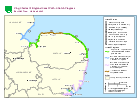
The map shows the stretches and provisional timings for improving coastal access in the east of England. Use the links in the table below to find out more information about each stretch.
| Stretch name | Progress |
|---|---|
| Harwich to Shotley Gate | Stage 4 and 5: Partially approved (not yet available for public use - work to establish the route is currently taking place on approved lengths) |
| Shotley Gate to Felixstowe Ferry: Priory Park to Shore Lane, Nacton |
Partially open to the public |
| Shotley Gate to Felixstowe Ferry: Bristol Hill to Priory Park and Shore Lane, Nacton to Felixstowe Ferry |
Stage 5: Open (not yet available for public use - work to establish the route is currently taking place) |
| Felixstowe Ferry to Bawdsey | Stage 4 and 5: Partially approved (not yet available for public use - work to establish the route is currently taking place on approved lengths) |
| Bawdsey to Aldeburgh | Stage 4 and 5: Partially approved (not yet available for public use - work to establish the route is currently taking place on approved lengths) |
| Aldeburgh to Hopton-on-Sea | Stage 4 and 5: Partially approved (not yet available for public use - work to establish the route is currently taking place on approved lengths) |
| Hopton-on-Sea to Sea Palling | Open to the public |
| Sea Palling to Weybourne | Open to the public |
| Weybourne to Hunstanton | Stage 4: Determine |
| Hunstanton to Sutton Bridge | Stage 5: Open (not yet available for public use - work to establish the route is currently taking place) |
| Sutton Bridge to Skegness | Stage 5: Open (not yet available for public use - work to establish the route is currently taking place) |
Last updated
-
Map updated to show that part of the Shotley Gate to Felixstowe Ferry is now (partially) open to the public.
-
Map and table updated to show that some sections of the Felixstowe Ferry to Bawdsey stretch have been approved.
-
Map and table updated to show the Hunstanton to Sutton Bridge stretch is now approved and is at stage 5.
-
Map and table updated to show that parts of the Aldeburgh to Hopton-on-Sea stretch and the whole of the Sutton Bridge to Skegness stretch have been approved.
-
Map and table updated to show part of the Bawdsey to Aldeburgh stretch has been approved.
-
Map and table updated to show that some sections of the Hunstanton to Sutton Bridge stretch have been approved.
-
Map and table updated to show that some sections of the Harwich to Shotley Gate stretch and the remaining sections of the Shotley Gate to Felixstowe Ferry are now approved.
-
Map and table updated to show the Bawdsey to Aldeburgh stretch is now at stage 4.
-
Map and table updated to show that some sections of the Shotley Gate to Felixstowe Ferry stretch have been approved.
-
Map and table updated to show that Felixstowe Ferry to Bawdsey is now at stage 4.
-
Map and table updated to show the Hunstanton to Sutton Bridge stretch is now at stage 4.
-
Map and table updated to show the Aldeburgh to Hopton-on-Sea stretch is now at stage 4.
-
Map and table updated to show the Harwich to Shotley Gate stretch is now at stage 4.
-
Map and table updated to show the Shotley Gate to Felixstowe Ferry stretch is now at stage 4.
-
Page updated to show Weybourne to Hunstanton stretch is now at stage 4.
-
Page updated to show that the Sutton Bridge to Skegness stretch is now at stage 4.
-
Table updated to show Shotley Gate to Felixstowe Ferry and Felixstowe Ferry to Bawdsey stretches are now at stage 2/3.
-
Updated table to show that Bawdsey to Aldeburgh stretch is now at stage 2/3.
-
Map and table updated to show work has started on the Felixstowe Ferry to Bawdsey and Bawdsey to Aldeburgh stretches.
-
Map and table updated to show work has started on the Shotley Gate to Felixstowe Ferry stretch.
-
Updated the map and table: Hopton-on-Sea to Sea Palling is now open to the public.
-
Replaced map with updated version.
-
Map updated to show change in provisional start dates for the Shotley Gate to Felixstowe, Felistowe Ferry to Bawdsey and Bawdsey to Aldebugh stretches.
-
Update to map: work has now started on the Aldeburgh to Hopton-on-Sea and Hunstanton to Sutton Bridge stretches.
-
New stretch started: Sutton Bridge to Skegness
Update history
2026-06-30 00:30
Map and table updated to show that further sections of the Aldeburgh to Hopton-on-Sea stretch, and the whole of the Bawdsey to Aldeburgh stretch are now open to the public.
2025-09-24 00:30
Map and table updated to show the Felixstowe Ferry to Bawdsey stretch is now open to the public.
2025-09-18 00:30
Map and table updated following the approvals of Aldeburgh to Hopton-on-Sea length 4 and Harwich to Shotley Gate lengths 2, 3, 5 and 6.
2025-07-09 00:30
Map and table updated as the Weybourne to Hunstanton stretch is now approved.
2025-05-08 09:36
Map and table updated following the approval of Bawdsey to Aldeburgh lengths 1, 2, 4 and 5.
2024-12-12 09:30
Map and table updated to show that parts of the Aldeburgh to Hopton-on-Sea stretch are now open to the public.
2024-10-16 00:15
Map and table updated to show the Shotley Gate to Felixstowe Ferry stretch is now open to the public.
2024-09-11 09:30
Map and table updated to show the Sutton Bridge to Skegness stretch is now open to the public.
2024-05-07 15:27
Map and table updated to show the Felixstowe Ferry stretch has been approved in full and work is now at stage 5.
2024-03-06 00:01
Map and table updated to show the Hunstanton to Sutton Bridge stretch is now open to the public.
2024-02-28 12:00
Map updated to show that part of the Shotley Gate to Felixstowe Ferry is now (partially) open to the public.
2023-05-05 09:00
Map and table updated to show that some sections of the Felixstowe Ferry to Bawdsey stretch have been approved.
2022-08-10 09:30
Map and table updated to show the Hunstanton to Sutton Bridge stretch is now approved and is at stage 5.
2022-06-23 09:00
Map and table updated to show that parts of the Aldeburgh to Hopton-on-Sea stretch and the whole of the Sutton Bridge to Skegness stretch have been approved.