Flooding impacts acrossfrom theheavy countryrainfall from Monday 23 September
Heavy rainfallrain forecastand overthunderstorms thefrom nextMonday 2423 hoursSeptember acrosshave theled countryto means significant river and surface water flooding isin possibleparts acrossof central England.
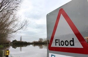
Heavy rainfallrain forecast over the next 24 hours across the country means significant river and surfacethunderstorms waterfrom floodingMonday is23 possibleSeptember acrosshave centralled England
Northamptonshire, Cambridgeshire, Worcestershire, Bedfordshire and Gloucestershire, amongst others, are likely to beflooding affected with minor impacts expected in other parts of SouthernEngland. EnglandThese andimpacts theincluded Northa withcombination river flooding is also possible on Friday in the north-east of England.
Atsurface 1pmwater on Thursday there were 27 flood warnings, showing flooding is expected, and 73some floodriver alerts,flooding. showingAround flooding200 is possible.
Heavy rain and thunderstorms earlier in the week has led to around 385 properties were flooded across Hertfordshire, Bedfordshire, Northamptonshire, Kent and the Home Counties.
With further rain coming, Environment Agency teamsstaff areremain out on the groundground, putting up flood defences, clearing blockages and supporting local authorities in their response work.
WeWith unsettled conditions expected during the coming few days, further flooding is possible but not expected on Thursday and Friday, so we continue to urge people to keep an eye on the weather, check their flood risk, and take care planning their journeys.
Kate Marks, Flood Duty Manager at the Environment Agency, said:
Heavy
Followingrainfallthisacrossweek’stheheavycountryrainmeansandthatthunderstorms,significantfloodriverwarningsand surfacealertswaterremainfloodinginimpactsplaceareacrosspossiblemanyin parts of centraltheEnglandcountry.todayTheandriskintoofFriday.furtherMinorsignificantriversurfacewaterflooding impactsisare also possiblebutnotexpectedin parts of north-easttheEnglandcountrytodayonThursdayand Friday.Environment Agency teams continue to be out on the ground, supporting local authorities in responding to surface water flooding. We urge people to plan their journeys carefully, follow the advice of local emergency services on the roads and not to drive through flood water – it is often deeper than it looks and just 30cm of flowing water is enough to float your car.
People should check their flood risk, sign up for free flood warnings and keep up to date with the latest situation as well as following @EnvAgency on X
X,formerlyTwitter,for the latest flood updates.
The FloodingEnvironment MinisterSecretary has been in Northamptonshire today visitedto communitiesmeet inEnvironment DunstableAgency andteams Leightonwho Buzzardhave been working with partners to hearprotect morecommunities aboutfrom the impacts earlierof thisflooding.
Secretary week.of OnState Wednesday,for Environment, Food and Rural Affairs Steve Reed said:
Myheartfeltsympathiesgotoallthoseaffectedbyfloodinginrecentdays.
TodayinNorthamptonI’veseenfirsthandthevitalworkthattheEnvironment SecretaryAgencyvisitedandNorthamptonshireemergencyonservicesWednesdayaredoingto receiveprotectacommunitiesbriefingfromonthetheirdangersofflooding.
TheGovernmentisworkingaroundtheclocktospeedupthebuildingofflooddefencesandboostouremergencyresponsethroughourFloodResilienceTaskforce.
The Environment Agency recognises the threat from surface water flooding and is taking action to improve the actionscountry’s takenresilience – for instance supporting local flood authorities to protectenhance communitieslocal locally.surface water flood risk mapping. See our blog on surface water flooding for more information.
Updates to this page
Last updated 26
-
Story updated to reflect latest situation
-
Updated to include statement from the Secretary of State
-
Updated as of 12.30pm Wednesday 25 September
-
Story updated 5pm Tuesday 24 September
-
Updated to reflect latest situation.
-
First published.