Forecasting floods with unprecedented detail
Flood forecasting with the open-source flood modelling tool High-Performance Integrated Hydrodynamic Modelling System (HiPIMS)

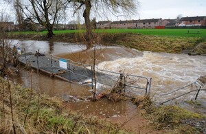
Flooding December 2015, Carlisle. Image credit: Environment Agency.
High-Performance Integrated Hydrodynamic Modelling System (HiPIMS) for flood forecasting and risk assessment
Qiuhua Liang 1 and Huili Chen 1
1 School of Architecture, Building and Civil Engineering, Loughborough University, United Kingdom
Professor Qiuhua Liang and his team at Loughborough University developed the award-winning High-Performance Integrated Hydrodynamic Modelling System (HiPIMS) over 2 decades. HiPIMS is an open-source flood modelling tool formally released at presentation in 2013. It was designed to better predict and understand flooding using high-performance computing. HiPIMS provides timely and detailed flood forecasts over an entire catchment or city.
The research filled a practical gap – forecasting highly transient flooding processes, driven by intense rainfall, dam breaks, storm surge or tsunamis. Flood predictions or forecasts are essential to assess and mitigate flood risk, and to develop effective plans for emergency response benefiting people at risk, government agencies, and other practitioners working on flood risk management (Xia, Liang and others, 2019).
Impact
HiPIMS was implemented and tested for forecasting the flooding process caused by the 2015 Storm Desmond over the entire Eden Catchment of 2500km². The real-time flood forecasting system was developed by integrating HiPIMS with the Met Office’s numerical weather prediction outputs. The system was able to forecast flooding from 36‐hour weather forecasts at a 10-metre resolution in 1.75 hours. This was the first real-time forecasting of a complete flooding process induced by intense rainfall, from rainfall-runoff, river hydraulics to inundation (Ming, Liang and others, 2020).
The output was showcased at the Royal Society’s Flooding From Intense Rainfall Programme Open Event in London on 27th November 2018, and recognised by Prof Brian Golding, the Senior Research Fellow in Weather Impacts from the Met Office, at the time as “the UK’s first real-time, high-resolution flood forecasting system of its kind”.

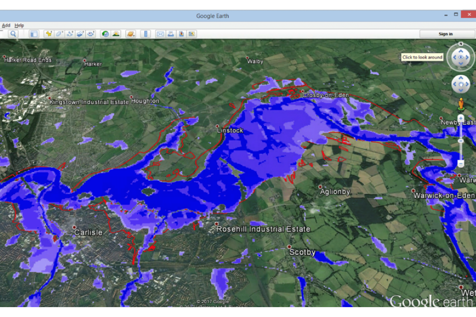
HiPIMS simulated flood map for the 2015 Desmond Flood in Carlisle. Credit: Qiuhua Liang.
HiPIMS was later embedded in the UK’s Data and Analytics Facility for National Infrastructure (DAFNI) for real-time flood forecasting through the NERC funded Flood-PREPARED and PYRAMID projects. It was also used to generate surface water flooding data to improve national infrastructure resilience in the National Digital Twin Programme (NDTP). The NDTP supports growing national capability in digital twinning technologies and processes throughout the UK.
Outside of the UK, HiPIMS has also been used to advance flood modelling and risk mapping practice. In China, the Ministry of Water Resources’ Institute of Water Resources and Hydropower Research (IWHR) incorporated HiPIMS into their Integrated Flood Modelling System (IFMS) to support national flood risk mapping across approximately 500,000km², almost half of the 1.1 million km2 of flood-prone areas in the country. The research developed as part of HiPIMS benefitted hundreds of millions of people in different provinces in China through provision of detailed flood risk information to better inform mitigation strategies (IWHR, 2023).
The Deputy Director from the Centre of Flood Control and Drought Relief at the China Institute of Water Resources and Hydropower Research (IWHR) (2023) said:
The numerical methods and model developed by Professor Qiuhua Liang have been directly applied to support national flood risk mapping in China. The flood risk maps have been used by the Central Government and local governments of different levels to inform flood risk management policy making and support flood protection planning and investment.
HiPIMS was adopted by government departments in Nepal to standardize methodologies for assessing Glacial Lake Outburst Flood (GLOF) risks (Chen, Zhao and others, 2022). The tool was featured in the RAINMAN-Toolbox, supporting heavy rainfall hazard assessments in central European catchments, showcasing its versatility across different geographic contexts.
The tool has received several awards, including the Prince Sultan Bin Abdulaziz International Prize for Water in 2024 recognising its innovation and impact. The award honours the development of pioneering, open-source, multi-GPU hydrodynamic models that support real-time flood forecasting at high temporal and spatial resolutions.
Resources
Chen H, Zhao J, Liang Q, and others. (2022). Assessing the potential impact of glacial lake outburst floods on individual objects using a high-performance hydrodynamic model and open-source data. Science of the Total Environment, 806(3): 151289. Available at: doi.org/10.1016/j.scitotenv.2021.151289 (Accessed: 24 March 2025).
HiPIMS-ocl Version 1 on GitHub. Available at: https://github.com/lukeshope/hipims-ocl (Accessed: 24 March 2024).
HiPIMS-CUDA Version 2 on GitHub. Available at: https://github.com/HEMLab/hipims (Accessed: 24 March 2025).
Loughborough University. (2025). HiPIMS history - UNESCO Chair in Informatics and Multi-hazard Risk Reduction. Available at: https://www.lboro.ac.uk (Accessed: 24 March 2025).
Ming X, Liang Q, and others. (2020). Real-time flood forecasting based on a high-performance 2D hydrodynamic model and numerical weather predictions. Water Resources Research. Available at: doi.org/10.1029/2019WR025583 (Accessed: 24 March 2025).
Smith LS, Liang Q (2013). Towards a generalised GPU/CPU shallow-flow modelling tool. Computers & Fluids, 88: 334-343. Available at: doi.org/10.1016/j.compfluid.2013.09.018 (Accessed 24 March 2025).
Xia X, Liang Q, and others. (2019). A full-scale fluvial flood modelling framework based on a high-performance integrated hydrodynamic modelling system (HiPIMS). Advances in Water Resources, 132: 103392. Available at: doi.org/10.1016/j.advwatres.2019.103392 (Accessed: 24 March 2025).
Funder
- UK Research and Innovation (UKRI)
- Loughborough University
Collaborators
- China Institute of Water Resources and Hydropower Research (IWHR)
- International Centre for Integrated Mountain Development (ICIMOD)
- UK Met Office
- Newcastle University
Research period
- 2013 to 2022
Impact period
- 2013 to 2022
Impact country
- UK
- China
- Nepal
Contributing towards the areas of research interest
- 4 - Flood incident management