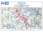
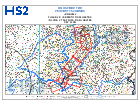
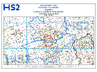
Property scheme maps for HS2 Phase 2b
Shows where the boundaries lie for the Phase 2b property schemes, covering Crewe to Manchester.
Manchester and the West Midlands to Leeds.
Documents


Details
Some of these maps are very large file sizes and, depending on your device and internet connection, may take a while to download.
The Homeowner Payment scheme only available for Phase 2b once this section of the route is authorised by Parliament.
Should you experience any problems, please contact the High Speed Two (HS2) helpdesk:
HS2 helpdesk
High Speed Two (HS2) Ltd
Two Snowhill
Snow Hill Queensway
Birmingham
B4 6GA
TheAs helpdeska teamresult areof unablerestrictions toin transferplace callsdue internally to HS2the LtdCOVID-19 membersoutbreak, ofwe staff.
Updatesstrongly torecommend thisyou page
-
Removed
enquiriesHS2receivedPhasevia2bpost.propertyTheschemehelpdeskmaps:teamWarwickshire,areStaffordshire,unableLeicestershire HS2toPhasetransfer2bcallspropertyinternallyschemetomaps: Nottinghamshire, Derbyshire, Nottingham HS2 PhaseLtd2bmemberspropertyofschemestaff.
Update history
2026-03-26 16:00
Removed HS2 Phase 2b property scheme maps: Dumfries and Galloway
2025-07-18 11:50
Removed HS2 Phase 2b property scheme maps: Warwickshire, Staffordshire, LeicestershireHS2 Phase 2b property scheme maps: Nottinghamshire, Derbyshire, Nottingham HS2 Phase 2b property scheme maps: Rotherham, Doncaster, Barnsley HS2 Phase 2b property scheme maps: Wakefield, Leeds, North Yorkshire
2023-05-24 10:01
Updated HS2 Phase 2b property scheme maps: Wakefield, Leeds, North Yorkshire.
2022-06-07 09:10
Safeguarding and property scheme maps, Directions and LPA Q&A have been updated following the issue of revised Safeguarding Directions on the P2b Western Leg in June 2022.