The Civil Hydrography Programme
The systematic survey of the UK’s coastal waters
Systematic surveying of the UK’s coastal waters is administered by the Maritime & Coastguard Agency (MCA) under the Civil Hydrography Programme, with technical oversight, data validation and onward charting undertaken by the UK Hydrographic Office. Under the programme, the MCA has issued a number of long-term commercial contracts to ensure accurate hydrographic information is gathered for updating the nation’s nautical charts and publications.
View the MCA Civil Hydrography Programme website.
Routine resurveys are undertaken in areas where the seabed is highly mobile. We analyse these surveys to identify changes that have occurred and apply updates to charts if necessary. We also assess whether the limits and survey frequency should be revised.
Analysis Reports - 2023 routine resurveys
View the Analysis Reports - 2023 routine resurveys
Analysis Reports - 2022 routine resurveys
View the Analysis Reports - 2022 routine resurveys
Analysis Reports - 2021 routine resurveys
View the Analysis Reports - 2021 routine resurveys
Analysis Reports - 2020 routine resurveys
View the Analysis Reports - 2020 routine resurveys
Analysis Reports - 2019 routine resurveys
View the Analysis Reports - 2019 routine resurveys
Analysis Reports - 2018 routine resurveys
View the Analysis Reports - 2018 routine resurveys
Analysis Reports - 2017 routine resurveys
View the Analysis Reports - 2017 routine resurveys
Analysis Reports - 2016 routine resurveys
View the Analysis Reports - 2016 routine resurveys
Analysis Reports - 2015 routine resurveys
View the Analysis Reports - 2015 routine resurveys
Analysis Reports - 2014 routine resurveys
View the Analysis Reports - 2014 routine resurveys
Analysis Reports - 2013 routine resurveys
View the Analysis Reports - 2013 routine resurveys
Analysis Reports - 2012 routine resurveys
View the Analysis Reports - 2012 routine resurveys
Analysis Reports - pre 2012 routine resurveys
View the pre 2012 analysis reports
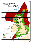
ADMIRALTY surveys of the UK (Q6090)
The ‘limited use’ chart Q6090 shows the limits and standards of ADMIRALTY surveys, including contract surveys to ADMIRALTY specifications around the United Kingdom. Not all of these surveys are available in digital format. For more detail on the availability of surveyssurveys, see our ADMIRALTY Marine Data Portal guide.