Information for boaters on- the River Great Ouse
Information about the River Great Ouse:Ouse including navigation notices, bridge heights, locks,lock dimensions, overhead power lines and facilities.
River conditions
TheYou can find current river conditions on Anglian Waterways: river conditions, closures and restrictions.
You can also:
- find out more about river advice for boaters
- register for the service
Some locks on the River Great Ouse are ‘reversed’ during floods and itshigh tributaries,flows. This closes the Riversaffected Cam,locks Lark,to Littlenavigation. Ouse,The Environment Agency strongly recommends that you don’t attempt to navigate during these periods.
When Strong Stream Advice is in force:
- signs along the river are displayed
- red LED ‘X’ lights activated at reversed locks, which, when lit mean to stay well clear and
Wisseyoff the river - some marinas and boat clubs also display red flags
About the river
The River Great Ouse and its tributaries provide approximately 255 kilometres of navigable waterway. It is the fourth longest river in the United Kingdom and flows through 5 counties:
- Northamptonshire
- Buckinghamshire
- Bedfordshire
- Cambridgeshire
- Norfolk
VisitIt is navigable from Bedford to the Wash at King’s Lynn with connections to the River Nene via the Middle Level.
There are also connections to the:
- River Cam
- River Lark
- Little Ouse
- River Wissey
- New Bedford River
- Old Bedford River
- Flood Relief Channel, from Denver Sluice to near King’s Lynn
Navigation notices
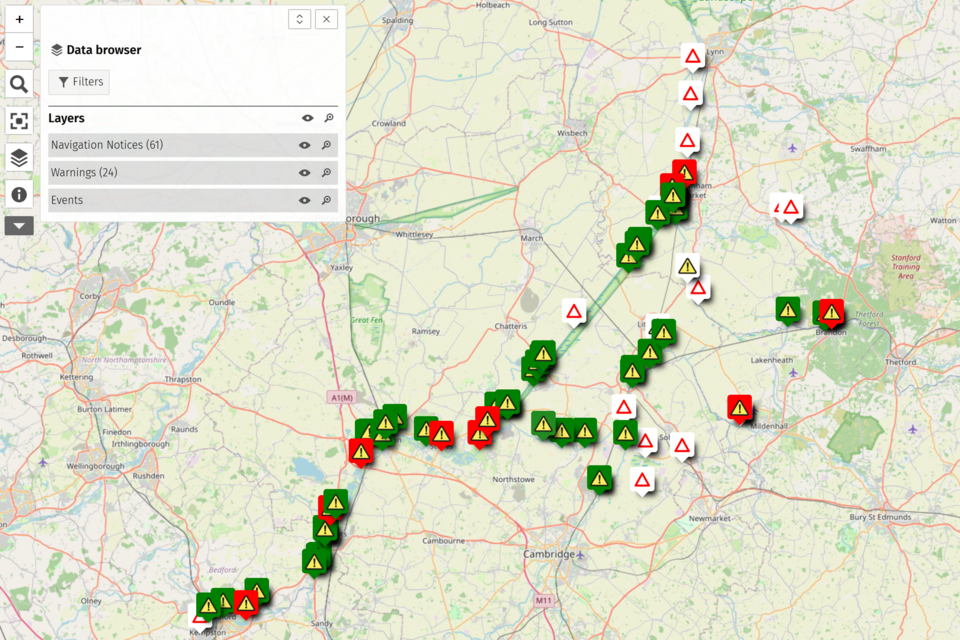
You can see the latest navigation notices on the River Great Ouse Mapping tool.
River Inspectors
- Bedford Ouse: 07717 423 512
- Ely Ouse and Stour: 07741 614 288
- Hermitage Lock: 01487 841 548
Useful information
Before you use the waterway you should read the Anglian navigation byelaws
You can find out more about the River Great Ouse by:
- reading the
- reading the
- visiting the Inland Waterways Association website to see the Fens Waterways map and read about the Waterways Link project.
Organising an event
ReadIf you want to organise an event on the AnglianRiver navigationGreat byelawsOuse you should read .
You can apply for an event using the waterway.Anglian Waterways event form
River Great Ouse bridge heights
On a river or waterway it is the person in charge of the boat (boat master) responsibility to ensure the boat can pass safely through the bridge. Sometimes, for example with bridge arches the clearance may be uneven and greater at some points across the channel than others. We usually state typical heights of the arches of bridges. These heights are usually the ones with the greatest clearance but other parts of the bridge may have much lower clearance.
Usually headroom, the space between the roof of the bridge and the rivers surface, is limited gauge boards are sometimes present. Theses boards are found up and down the stream of the bridge to show the space available, these should be used. The boat master should know if the height of their boat is above the waterline. Remember to measure this to the boats highest point which may include; masts, chimneys or aerials for example.
Useful aids such as ‘tell tales’ can also be purchased from chandlers or boat shops. These are an extendable, usually flexible pole that can be mounted to the bow and furthest forward point of a boat. You also need to set the highest point of the boat with a marker at the tip. This type of device can then give a useful indication to the boat master under any low structures over the river if their boat will fit beneath. You must approach with extreme caution and dead slow taking account of any flow that may be naturally present in the waterway for this to work. Such aids may not offer much assistance if approaching low bridges or structures from the upstream side under any degree of river flow. It is essential for safety that boat masters are satisfied there are no headroom issues. Especially if on the river in any heightened level or flow conditions such as after periods of rainfall.
Water levels especially on rivers when compared to canals do go up and down, sometimes significantly. The information provided on bridge heights is provided as an indicative guide only and available headroom may be significantly less or sometimes more than what is stated. It is the boat masters responsibility to ensure the safety of their boat and those on board at all times. Information provided is intended as guidance and should be read in conjunction with the gov.uk Terms and Conditions information.
Bedford Ouse: Bedford to Hermitage
| Location | Headway (metres) | Headway (feet) |
|---|---|---|
| Charter Walk / St Mary’s Embankment Footbridge | 3.0 | 9’9” |
| Bedford Lock Footbridge | 2.38 | 7’9” |
| Engineers Footbridge | 2.1 | 7’0” |
| Road Bridge | 2.7 | 8’10” |
| Footbridge | 2.9 | 9’6” |
| Old Railway Footbridge | 2.3 | 7’6” |
| Road and Pipe Bridge | 2.7 | 8’10” |
| Sewage Works Bridge | 2.6 | 8’8” |
| Railway Bridge | 2.6 | 8’8” |
| A421 Road Bridge | 6.2 | 20’4” |
| Footbridge | 4.4 | 14’5” |
| Road Bridge (GT Barford) | 3.0 | 9’9” |
| Footbridge | 4.5 | 14’9” |
| Tempsford Old Road Bridge | 3.1 | 10’1” |
| Tempsford New Road Bridge | 3.7 | 12’ |
| A428 Road Bridge | 6.1 | 20’ |
| Eaton Socon Lock Footbridge | 2.7 | 9’ |
| St Neots Town Bridge | 2.8 | 9’2” |
| St Neots Paper Mill Bridge (B1041 Road Bridge) | 2.9 | 9’5” |
| Offord Lock Bridge | 2.5 | 8’1” |
| Railway Bridge | 4.8 | 15’9” |
| A14 Road Bridge | 5.5 | 18” |
| Huntingdon Bridge | 3.4 | 11’2” |
| Hemingford Lock Bridge | 2.7 | 8’10” |
| St Ives Town Bridge | 2.7 | 8’10” |
| A1096 Road Bridge | 4.1 | 13’5” |
| Rail Bridge | 3.8 | 12’5” |
| Hermitage Lock | 3.4 | 11’1” |
Old West: Popes Corner to Hermitage Lock
| Location | Headway (metres) | Headway (feet) |
|---|---|---|
| Railway Bridge | 3.6 | 11’9” |
| Wicken Road Bridge | 3.2 | 10’6” |
| Green End Road Bridge | 3.5 | 11’5” |
| Lazy Otter Road Bridge | 3.2 | 10’6” |
| Cambridge A10 Bridge | 3 | 9’10” |
| Twentypence Road Bridge | 3.3 | 10’8” |
| Aldreth High Bridge | 4 | 13’1” |
| Willingham Flat Bridge | 3 | 9’10” |
| Hermitage Lock Road Bridge | 3.4 | 11’1” |
Ely Ouse
| Location | Headway (metres) | Headway (feet) |
|---|---|---|
| Ten Mile Rail Bridge | 4 | 13’1” |
| Hilgay Road Bridge | 4 | 13’1” |
| Littleport A10 Road Bridge | 3.4 | 11’1” |
| Sandhills Road Bridge | 3.45 | 11’3” |
| Queen Adelaide Road Bridge | 3.16 | 10’4” |
| Queen Adelaide Rail Bridge | - | - |
| Potters Road Bridge | 3.4 | 11’1” |
| Potters Foot Bridge | 3.5 | 11’4” |
| Railway Bridge d\s of Ely, Willow Walk | 3.1 | 10’1” |
| Loveys Road Bridge | 3.25 | 10’8” |
| Railway Bridge u\s at Ely | 3.06 | 10’ |
| Ely High Bridge | 3.19 | 10’5” |
| Newmarket Railway Bridge | 3.15 | 10’4” |
River Cam: Popes Corner to Jesus Lock
| Location | Headway (metres) | Headway (feet) |
|---|---|---|
| Dimmocks Cote Road Bridge | 3.7 | 12’1” |
| Dimmocks Cote Road Bridge | 3.1 | 10’2” |
| Clayhithe Road Bridge | 3.4 | 11’1” |
| Baitsbite Lock | 3 | 9’10” |
| A14 Road bridge | 4.9 | 16’ |
| Stourbridge Footbridge | 3.2 | 10’6” |
| Elizabeth Road Bridge | 4.9 | 16’ |
| Midsummer Common Foot Bridges x2 | 3 | 9’10” |
| Victoria Road Bridge | 3.2 | 10’6” |
| Jesus Lock | 4 | 13’1” |
The Lodes
| Location | Headway (metres) | Headway (feet) |
|---|---|---|
| Upware Lock and Road Bridge, Reach Lode | 2.7 | 8’10” |
| Wicken Lode Foot Bridge | 2.7 | 8’10” |
| High Bridge, Burwell Lode | 2.7 | 8’10” |
| The Anchor Road bridge, Burwell | 2.5 | 8’2” |
River Lark: Ely Ouse to Judes Ferry
| Location | Headway (metres) | Headway (feet) |
|---|---|---|
| Branch Bridge | 3.4 | 11’1” |
| Railway Bridge, Prickwillow | 2.6 | 8’6” |
| Prickwillow Road Bridge | 2.6 | 8’6” |
| Isleham Lock | 2.65 | 8’69” |
| Judes Ferry | 3.2 | 10’6” |
Little Ouse: Ely Ouse to Brandon
| Location | Headway (metres) | Headway (feet) |
|---|---|---|
| Brandon Creek A10 Road Bridge | 3.1 | 10’2” |
| Little Ouse Village Road Bridge | 3.1 | 10’2” |
| Redmere Farm Road Bridge | 3 | 9’10” |
| Hockwold Sluice | 3 | 9’10” |
| Railway Bridge d\s Brandon | 2.7 | 8’10” |
| Brandon Lock | 2 | 6’6” |
River Wissey: Ely Ouse to Whittington
| Location | Headway (metres) | Headway (feet) |
|---|---|---|
| Railway Bridge | 2.7 | 8’10” |
| Hilgay A10 Road Bridge | 2.6 | 8’6” |
| Hilgay Old Road Bridge | 2.6 | 8’6” |
| Wissington Foot Bridge | 3 | 9’10” |
| Wissington Beet Factory Pipe Bridge | 3.2 | 10’6” |
| Wissington Beet Factory Old Road Bridge | 3.5 | 11’5” |
| Wissington Beet Factory New Road Bridge | 4 | 13’1” |
| Stoke Ferry Sluice | 3 | 9’10” |
| Stoke Ferry Road Bridge | 2.5 | 8’2” |
| Whittington Road Bridge | 2.9 | 9’6” |
River Great Ouse locks
There are 22 locks on the River Great Ouse and its tributaries.
Lock dimensions
| Name | Lock length (metres) | Lock length (feet) | Lock width (metres) | Lock width (feet) | Lock depth (metres) | Lock depth (feet) | Lock headroom (metres) |
|---|---|---|---|---|---|---|---|
| Bedford lock | 29.7 | 97’ 5” | 3.3 | 10’ 9” | 1.1 | 3’ 7” | 2.05 |
| Cardington lock | 28.5 | 93’ 6” | 3.11 | 10’ 1” | 1.15 | 3’ 9” | 2.75 |
| Castle Mills lock | 29.5 | 96’ 9” | 4 | 13’ 1” | 1.2 | 3’ 11” | 4.3 |
| Willington lock | 29.5 | 96’ 9 | 4 | 13’ 9” | 1.3 | 4’ 3” | - |
| Great Barford lock | 29.5 | 96’9” | 4 | 13’ 1” | 1.2 | 3’ 11” | 4.55 |
| Roxton lock | 26 | 85’ 4” | 4 | 13’1” | 1.15 | 3’ 9” | 2.75 |
| Eaton Socon lock | 31.5 | 103’ 4” | 3.3 | 10’ 9” | 1.6 | 5’ 2” | 2.7 |
| St Neots lock | 32.9 | 177’ 1” | 3.3 | 14’ 1” | 1.05 | 3’ 11” | 3.2 |
| Offord lock | 30.5 | 100’ | 3.4 | 11’ 1” | 1.2 | 3’ 11” | 2.5 |
| Brampton lock | 31.7 | 104’ | 3.4 | 11’ 1” | 1.45 | 4’ 9” | 2.8 |
| Godmanchester lock | 30.5 | 100’ | 4 | 13’1” | 1.1 | 3’ 5” | 2.75 |
| Houghton Lock | 37.5 | 90’ 3” | 3.65 | 11’ 11” | 1.5 | 4’ 11” | 2.75 |
| Hemingford lock | 28 | 91’ 10” | 3.85 | 12’ 7” | 1.5 | 4’ 11” | - |
| St Ives lock | 31.3 | 102’8” | 3.35 | 10’ 11” | 1.5 | 4’ 11” | - |
| Brownshill lock | 30 | 98’ | 4 | 13’ 1” | 1.5 | 4’ 11” | 3 |
| Hermitage lock | 30.5 | 100’ | 4 | 13’1” | 1.5 | 4’ 11” | 2.75 |
| Bottisham lock | 29.8 | 97’ 7” | 4.5 | 14’ 7” | 1.5 | 4’ 11” | - |
| Upware lock | 18.7 | 61’ 3” | 4.3 | 14’ 1” | 1.3 | 4’ 2” | - |
| Isleham lock | 26.8 | 87’9” | 4.55 | 14’ 9” | 1 | 3’ 2” | - |
| Brandon lock | 12.4 | 40’ 6” | 3.7 | 12’ 1” | 1.4 | 4’ 5” | - |
| Denver lock | 39.5 | 96’ 7” | 5.4 | 17’ 7” | 2.04 | 6’ 6” | - |
| Relief |
30 | 98’ 4” | 4.6 | 15’ | 2 | 6’ 5” | 2.75 |
| Jesus lock* | 32 | 104’ 9” | 3 | 9’ 8” | 1.4 | 4’ 5” | - |
| Baits |
32 | 104’9” | 4.3 | 14’ 1” | 1.2 | 3’ 9” | - |
Distances between locks
| Name | Distance to next lock downstream (kilometres) | Distance to next lock downstream (miles) | Cruising time to next lock downstream (minutes) | Facilities |
|---|---|---|---|---|
| Bedford lock | 5 | 3.1 | 45 | - |
| Cardington lock | 2 | 1.24 | 30 | - |
| Castle Mills lock | 4.5 | 2.79 | 40 | - |
| Willington lock | 1.5 | 0.93 | 25 | - |
| Great Barford lock | 3 | 1.86 | 35 | water tap |
| Roxton lock | 8 | 4.97 | 1hr 30 | - |
| Eaton Socon lock | 3.2 | 1.99 | 40 | - |
| St Neots lock | 6.5 | 4.04 | 1hr | - |
| Offord lock | 3 | 1.86 | 35 | refuse disposal |
| Brampton lock | 2 | 1.24 | 30 | - |
| Godmanchester lock | 6 | 3.73 | 50 | - |
| Houghton Lock | 2.5 | 1.75 | 30 | - |
| Hemingford lock | 3 | 1.86 | 35 | - |
| St Ives lock | 8 | 4.97 | 1hr 30 | refuse disposal |
| Brownshill lock | 3.5 | 2.17 | 40 | - |
| Hermitage lock | 23 | 14.29 | 4hr 10 | refuse disposal, toilets, showers, water tap, lock keeper |
| Bottisham lock | 15 | 9.32 | 1hr 30 | - |
| Upware lock | 4.6 | 2.86 | 60 | - |
| Isleham lock | 16 | 9.94 | 2hr 30 | - |
| Brandon lock | 22 | 13.67 | 4hr | - |
| Denver lock and Complex | 18 | 11.18 | 4hr | pump out, refuse disposal, Elsan disposal, water tap, toilets, slipway, lock keeper |
| Jesus lock* | 25 | 15.53 | 3hr | pump out, refuse disposal, water tap |
| Baits |
21 | 13.05 | 2hr 15 | - |
*Jesus lock and Baits biteBite lock are managed by Conservators of the River Cam.
Speed limits
All speed limits are indicated on the River Great Ouse and its tributaries by signage.
Speed limits on the Great Ouse vary between 4 miles per hour (6.4 kilometres per hour) to 7 miles per hour (11.2 kilometres per hour ). On the tidal section of the river the speed limit is 15 miles per hour (24.1 kilometres per hour).
There are a number of speed indication systems on the Ely Ouse and Old West River to make the river safer. 2 transit posts have been placed at certain points on the riverbank and serve as speed markers. When travelling between the 2 posts it should take at least 30 seconds or longer. If it takes less time than this then you’re speeding and must slow down.
Speeding can cause unnecessary wash, erosion and harm wildlife as well as damage to other boats and the speeding boats themselves. We operate regular patrols and undertake speed monitoring activities and enforcement on the rivers where necessary. We do this to encourage compliance and make the river safer and more pleasurable for all river users.
Request a speed exemption
To request a speed exemption you should read .
You can apply for a speed exemption using the Anglian Waterways speed limit exemption form
Overhead power lines
There are headroom restrictions from overhead power lines on the River Great Ouse.
Because river levels change and overhead power line heights vary, we cannot provide the heights of power lines.
Some network operators specify exclusion zones around power lines, depending on the voltage being transmitted. This is to prevent electricity arcing or jumping from a transmitting wire to a boat mast, for example.
If your vessel has raised masts, radio aerials or booms you should contact the local electricity network operator before using the waterway.
For more safety advice see theNational EnergyGrid Networks- AssociationSailing guide ‘Safety information for watersports’safety.
River advice for boaters and Strong Stream Advice
Locks
Updates on the rivers Nene and Great Ouse are ‘reversed’ during floods and high flows. This closes the affected locks to navigation.this Thepage
-
Updated
periods.pageWhenwithstrongcontentstreamonadviceisinforce,signsalongtheareconditions,displayedspeedandforms,redeventsLED‘X’lightsactivatedatreversedlocks.Whenlittheselightsmeantostaywellclearofftheriver,somemarinasandboatclubsalsodisplayredflags.TofindoutthelatestriveradviceforboaterscalltheFloodlineinformationservicetofindoutwhatstatustheriverisinforboating.Thestatusare,normalandnowarningsinforce,cautionwhichmeanstobeawareandStrongStreamAdvicewherelocksareclosedandisstronglyadvisedagainst.notices.Tofindoutmore;TelephoneFloodline:03459881188Selectoption1andthenoption1again,whenprompted;RiverNenequickdialnumber:032112RiverGreatOuse,BedfordOusefromKempston(Bedford)toStIvesTownquickdialnumber:033211RiverGreatOuse,BedfordOusefromStIvesLocktoHermitageLockatEarithquickdialnumber:033212MooringReadtheAnglianwaterwaysguideforinformationonmooring.
-
There has been additional information added including Strong Stream advice.