A guide to Forestry Commission’s sensitivity maps for woodland creation
Find
Learn outhow about our series of sensitivity maps whichcan indicatehelp whereyou therefind areout likelyif toyour beland feweris sensitivitiessuitable tofor woodland creation inand England.
Applies to England
You can view all the sensitivity maps on the Forestry Commission’s map browser, under ‘land sensitivity’.
Sensitivity maps for woodland creationOverview
We have developed a series of sensitivity mapsmaps, based on nationally available and consistent spatialdatasets data. These maps will help to indicate whetherwhere there isare likely to be potentialfewer to establish new woodland on land parcels or where there may be sensitivities thatto would prevent tree planting or woodland creation.
WhereThese thewill mapshelp showlandowners identify whether there is apotential lowto sensitivityestablish tonew woodland creation,on thistheir doesland notand guaranteewhere thatthere wemay willbe approvesensitivities planting.that However,would thepreclude lowplanting sensitivityor areasinfluence dowoodland notdesign. haveIf anythere clearare constraintsno toobvious addresssensitivities, onregulatory the basis of national datasets, and itgrant shouldprocessing beis easierlikely to agreebe creatingfaster newif woodlandcomplete hereapplications thanare in other areas.submitted.
Likewise,The creationmaps ofdo newnot woodland,indicate particularlythat, ofwhere nativethere woodland,is maya below appropriatesensitivity outsideto ‘lownew sensitivity’woodland, areas.planting We will determinebe theagreed appropriatenessas ofappropriate proposalsby inthe theseForestry areas.Commission, Whereresponding relevant, we will respond to the views of Natural England, Environment Agency, Historic England, the local authority and other stakeholders.
The sensitivityLikewise, mapsplanting/establishment excludeof allnew landwoodland thatmay isbe unsuitableappropriate, forparticularly planting,of fornative examplewoodland, landoutside mapped‘low assensitivity’ urbanareas.
England areas,Woodland existingCreation woodland,Offer assumed(EWCO) woodland,fast ortracking
The habitatslow thatsensitivity aremap consideredfor toowoodland wet,creation oris tooused rockyto ordefine tooeligibility saltyfor toEWCO’s supportfast-track theprocess growthand ofassociated trees.low Thissensitivity island achievedpayment.
Eligibility byfor restrictingboth the sensitivityfast mapstrack toand thelow followingsensitivity land covers,payment basedwill oncontinue theto mostbe recentbased updateon ofversion Landcover4.0 Mapof (UKthe Centre‘low sensitivity’ for Ecologyapplications andreceived Hydrology,before 2021):1 January 2027.
acidApplications
grasslandarablereceivedandafterhorticulturecalcareous1grasslandheatherheatherJanuarygrasslandimproved2027grasslandneutralforgrassland
Variantsboth offast-tracking and the fulllow sensitivity mapland andpayment lowwill sensitivitybe mapbased on version 4.0
5.0.
WeFind haveout alsomore developedabout 3EWCO variantsfast oftracking and the fulllow sensitivity mapland andpayment.
Introduction associatedto low sensitivity map,maps whichfor assignwoodland lowcreation sensitivityversion status5.0
This topage eitherprovides onethe ormetadata bothfor a series of 2related geospatial datasets that areidentify treatedquantified asassessments mediumof sensitivity in the fullrelative sensitivity map,of asplaces setfor outnew below:
England woodland creation lowacross sensitivityall mapof versionEngland. 4.0Their variantpurpose 1
agriculturalislandtoclassinform3a:decisionschangedontoproposalslowforsensitivityprotectednewlandscapesplanting(NationalofParkswoodland.The
andresultantNationalgeospatialLandscapes):datasetschanged(maptolayers)lowhavesensitivity
Englandbeen woodlandcreated creationfrom lowan sensitivityanalysis mapof versiona 4.0range variantof 2
agriculturalotherlandmapclasslayers3a:andremainingallocatemediumallsensitivityprotectedlandlandscapes:inchangedEngland according tolowits sensitivity
England to woodland creation lowinto sensitivityone mapof version4 4.0 variant 3
categories:
agriculturallandClass3a:changedtoprotectedmediumlandscapes:sensitivity- high
remainingsensitivity - unsuitable
mediumforsensitivitywoodland creation
The variantslow ofsensitivity category has additionally been used to derive the full‘England andwoodland creation low sensitivity mapsmap’ havegeo-spatial beendata developedlayer because,to inhelp thelandowners caseand ofgrant agriculturalapplicants landengage quality,with theplanting decisionnew towoodlands.
At plantthe ontime theof bestpublish and(October most2026) versatilethe landlow issensitivity largelymap anfor economicwoodland decisioncreation madeversion by5.0 thedescribed landowner.on Variantsthis 1page andis 3similar revealin underlyingname sensitivitiesto ofbut ALC3ashould land.not Forbe protectedconfused landscapes,with wherethe woodland‘low creationrisk maymap befor desirable,woodland particularlycreation’ ofthat nativeremains woodland,in variantsforce 1as andthe 2formal revealmap sensitivitiesof toreference woodlandfor creationthe otherEnvironmental thanImpact protectedAssessment landscape(EIA) status.regulations.
Relationship with the low-risk map for woodland creation
The low sensitivity map v4.0version 5.0 is a development of the low-risk map for woodland creation, as defined in the Environmental Impact (Forestry) Regulations (2017), with the main differences set outas below:follows:
-
all areas of peat included in Natural England’s England peat map are excluded from the low sensitivity map (and its variants), with deep peat classified as
high‘highsensitivitysensitivity’ and shallow peat and other soils with peaty pockets classified asmedium‘mediumsensitivitysensitivity’ -
areas of land included in the wader zonal maps for curlew and golden plover as strata 2 to 5 are excluded from the low sensitivity map (and its variants), with strata 4 and 5 treated as high sensitivity and strata 2 and 3 as medium sensitivity
-
areasamendedofbufferslandare,includedthesomewoodcases,pastureappliedandtoParklandSitesPriorityofHabitatSpeciallayerScientificareInterest,excludedSpecialfromprotectiontheAreas,lowSpecialsensitivityAreasmapof(andConservationitsandvariants)RAMSAR sites -
areasintegratedofwaterlandbodiesincludedthatinare vulnerable to water resource constraints where existing woodland cover of thehistoricrelevantenvironmenttyperidgeisandmorefurrowthanlayer20% are treated as medium sensitivity and excluded from the low sensitivity map(anditsvariants). -
amendedlandbuffersincludedare,somethecases,enhancedappliedSelectedtoHeritageSitesInventoryofforSpecialNaturalScientificEnglandInterestgeospatial(SSSIs),layerSpecialisProtectiontreatedAreasas(SPAs),mediumSpecialsensitivityAreasofConservation(SACs)Ramsarexcludedsites:fromdetailsofbufferlowthatappliestoeacharesetoutinthesectionSummaryofthetypesofWoodlandCreationmapsmap -
somelayershavealsobeenupdated,includingPriorityHabitatInventory
The low-risk map for woodland creation will continue to be used for meeting the requirements of the 2017 EIA (Forestry) regulations in terms of determining where notification may apply, rather than EIA screening.screening; However,however, the full and the 3 low sensitivity maps represent a more current view of sensitivities to woodland creation.creation
NationalWhat’s breakdownchanged ofbetween land4.0 sensitivityand for5.0 woodlandof creation
the sensitivity maps
NationalVersion statistics5.0 has been developed from version 4.0 of landthe sensitivity maps with the following changes:
- the Selected Heritage Inventory for Natural England (SHINE) geospatial layer has been added as an additional sensitivity – any of the
full3 categories (low, medium andlowhigh) are categorised as medium sensitivity - a
mapsgeospatial layer identifying Integrated Water Bodies (IWBs) that aregivenvulnerableintoTablewater1,resourceincludingconstraintsforhas been added as an additional sensitivity – IWBs where the3relevantvariants.woodland cover (conifer or all woodland) exceeds 20% have been categorised as medium sensitivity - the 2024 Land Classification Map has been incorporated as an update
- the 2024 National Forestry Inventory has been incorporated as an update
National breakdown of land sensitivity for woodland creation
Table 1. National breakdown of land sensitivity for the England woodland creation full sensitivity map v4.0,version 5.0, the low sensitivity map v4.0 (restricted to blocks more than 2 hectares in area) derived from it,it and the 3 variants.variants.
| Sensitivity map | Variant | Sensitivity | Area of England (hectares) | |
|---|---|---|---|---|
| Full sensitivity map v4.0 | None | Unsuitable | ||
| Low | ||||
| Medium | ||||
| High | ||||
| Low sensitivity map v4.0 | Restricted to |
Low | ||
| Full sensitivity map v4.0, variant 1 | Unsuitable | |||
| Low | ||||
| Medium | ||||
| High |
||||
| Full sensitivity map v4.0, variant 2 |
ALC 3a: medium sensitivity protected landscapes: |
Unsuitable | ||
| Low | ||||
| Medium | ||||
| High | ||||
| Full sensitivity map v4.0, variant 3 |
ALC 3a: low sensitivity protected Landscapes: |
Unsuitable | ||
| Low | ||||
| Medium | ||||
| High |
Potential area for woodland creation
Any land that falls under the following land classifications in the UK Centre for Ecology and Hydrology (UKCEH) Land Cover Map 2024 (25m raster):
| Type | Land classification identifier |
|---|---|
| Acid grassland | 7 |
| Arable and horticulture | 3 |
| Calcareous grassland | 6 |
| Heather | 9 |
| Heather grassland | 10 |
| Improved grassland | 4 |
| Neutral grassland | 5 |
The following non-woodland components of the National Forest Inventory are also included:
- agriculture land
- bare area
- grassland
- low density
- other vegetation
- shrub
Summary of the types of woodland creation sensitivity maps
The datasets now available are:
England woodland creation full sensitivity map v4.0
v5.0
This dataset is the product of geospatial analysis to identify areas that may have sensitivities that need to be considered when creating new woodland in England. It identifies places regarded as either:
lowLowsensitivitysensitivity.mediumMediumsensitivitysensitivity.highHighsensitivitysensitivity.unsuitableUnsuitable (for woodlandcreation)creation).
The full sensitivity map covers all of England to the high-water mark with the entire country assigned to one of the four categories set out above.
England woodland creation low sensitivity map v4.0
v5.0
This dataset is based on a subset of the ‘England woodland creation full sensitivity map v4.0’v5.0’ dataset, for England, showing only land regarded asas:
1a. low sensitivity (as in the full sensitivity map), but with the additional criteria that these areas are greater than 2 hectares in extent.
Three variants of the low sensitivity map are also presented:presented, further detail follows in the relevant sections:
1b. England woodland creation low sensitivity map
v4.0v5.0-– variant 11c. England woodland creation low sensitivity map
v4.0v5.0-– variant 21d. England woodland creation low sensitivity map
v4.0v5.0-– variant 3
The low sensitivity map covers all of England to the high-water mark and shows where the land is assigned as low sensitivity according to the respective criteria for the specific map asthat fully detailed below.follows.
WoodlandWhat Creation Opportunity Area
Any land that falls under the followingsensitivity landmaps classifications in the UK Centre for Ecology & Hydrology (UKCEH) Land Cover Map 2020 (25 m raster):
The followingEngland non-woodlandwoodland componentscreation offull thesensitivity Nationalmap Forest Inventory are also included:v5.0
agriculturelandbaregroundgrasslandlowdensitytreecoverothervegetationshrub
How land is classified unsuitable or low, medium, high sensitivity
Extent: England
Format: Raster grid,grid. polygonPolygon format is also availableavailable.
Grid resolution: 25 metres by 25 metres
LandLow that is low sensitivity land for woodland creation
Land with a low sensitivity for woodland creation is defined in this map layer as land with any one or more of the following designations:
It is not:
- unsuitable
- high sensitivity for woodland creation
- medium sensitivity for woodland creation
It is also within land from the following land cover categories of the Land Cover Map (2021)(2024) (LCM) published by the UK Centre for Ecology & Hydrology (UKCEH)::
- acid grassland
- arable and horticulture
- calcareous grassland
- heather
- heather grassland
- improved grassland
- neutral grassland
The following non-woodland Interpretedinterpreted Forestforest Typestypes (IFTs) from Forest Research’s National Forest Inventory (NFI) woodland map (2020)(2024) are also included:
- agriculture land
- bare
groundarea - grassland
- low density
treecover - other vegetation
- shrub
LandMedium that is medium sensitivity land for woodland creation
Land with a medium sensitivity for new planting of woodland is defined in this map layer as land with any one or more of the following designations:
It is not:
- unsuitable
- high sensitivity for woodland creation
It is also in map layers defined as:
acidAcid vulnerablecatchments:catchments.catchmentsCatchments are assessed for acid vulnerability using theWaterwaterFrameworkframeworkDirectivedirective classification of water quality, published by the Environment Agency. We define acid vulnerability from the results for pH (one element of thePhysico-Chemicalphysico-chemicalQualityquality test) and both fish andinvertebrates,invertebrates which are elements of the biological quality test (i.e. all areas defined as ‘FAIL’, or ‘FAIL_BIO’ in the 2019data)AgriculturalLandClass(ALC):. In areas ALC 1, or ALC 2 or ALC 3a as defined in the provisional agricultural land classification.- National
Landscapes,landscapespreviously(previouslyknownasBeauty(AONBs)Beauty). - Birdlife International Important Bird
Areas(IBAs)Areas. - Countryside
StewardshipStewardship.(CS):CSCountrysideschemeStewardshipagreementsScheme Agreements with end dates later than 31 December2021;2021 plus b) Land parcels in all Higher-tieragreementsagreements. - Countryside Right of Way (
CROWCRoW) Act 2000-– S4 Conclusive Registered CommonLandLand. - Environmental Stewardship Higher Level
Agreementsagreements. - Local
NaturenatureReserves(LNRs)reserves. - National
Parksparks(NPs)and the Broads. - Natural England
peatPeatmap:Mapon(2008). On land with either shallow peaty soils = medium sensitivity and other soils with peaty pockets = mediumsensitivitysensitivity. - Priority Habitat
Inventory:Inventory.inIn places that are any one or more of thefollowing:following, fragmented heath, grass moorland, good quality semi-improvedgrasslandgrassland. - Wader Zonal Map for
goldenGoldenploverPlover andcurlewCurlew breeding wading bird species (a combined layer showing highest sensitivity for eitherspecies):species). In either strata 2 or strata 3 areas (i.e. mediumsensitivity)sensitivity). ridgeRidge andfurrow:furrow.ridgeRidge and furrow with no bufferapplied:applied.detectionDetection areasonlyonly.
LandSHINE. thatAny isof highthe three categories (low, medium and high).
High sensitivity land for woodland creation
Land with a high sensitivity for new planting of woodland is defined in this map layer as land within any one or more of the following designations:
It is not unsuitable.
It is also within:
NationalnationalNaturenatureReservesreserves- Natural England
peatPeatmap:Map.inIn areas of deep peaty soils - Priority Habitat
Inventory:Inventory.withinWithin other than fragmented heath, grassmoorland,moorland and good quality semi-improved grassland RamsarRAMSARsites:sites.in,In, or within a700700mmile- registered
battlefields:battlefields.in,In, or within a200200mmile - registered parks and
gardens:gardens.in,In or within a200200mmile - scheduled
monuments:monuments.in,In or within a200200mmile - Special Protection
AreasAreas:(SPAs):inin,2,0002,000mmile - Sites of Special Scientific
InterestInterest.(SSSIs):Ifif1,0001,000mmile - Sites of Special Scientific
InterestInterest.(SSSIs):Ifif250250mmile - Special Areas of
ConservationConservation.(SACs):Ifif700700mmile - Special Areas of
ConservationConservation.(SACs):Ififathe250250mmile - Wader Zonal Map for
goldenGoldenploverPlover andcurlewCurlew breeding wading bird species (a combined layer showing highest sensitivity for eitherspecies):species).inIn either strata 4 or strata 5 areas (i.e. high sensitivity) WorldworldHeritageheritageSite:site.in,In, or within a200200mmile- wood pasture and parkland priority
habitat:habitat.allAll categories
Land that is unsuitable for woodland creation
Land that is unsuitable for new planting of woodland is defined in this map layer as land with any one or more of the following designations:
designations based on Land Cover Map (2021)(2024) (LCM) from the UK Centre for Ecology & Hydrology (UKCEH): Inwith placesthe definedfollowing as:land classifications:
| Type | Land classification identifier | ||
|---|---|---|---|
| Bog | 11 | ||
| Coniferous woodland | 2 | ||
| Deciduous woodland | 1 | ||
| Fen | 8 | ||
| Freshwater | 14 | ||
| Inland rock | 12 | ||
| Littoral rock | 17 | ||
| Littoral sediment | 18 | ||
| Saltmarsh | 19 | ||
| Saltwater | 12 | ||
| Suburban | 21 | ||
| Supralittoral rock | 15 | ||
| Supralittoral sediment | 16 | ||
| Urban | 20 |
NationalOr Forestany Inventoryof (NFI)the woodlandfollowing mapinterpreted (2020)forest types from the National Forest Research.Inventory woodland Themap following(2024) Interpretedfrom Forest Types (IFTs):Research:
- assumed woodland
- broadleaved
- conifer
- coppice
- coppice with standards
- failed
- felled
- ground prep
- mixed mainly broadleaved
- mixed mainly conifer
- open water
- quarry
- river
- road
- uncertain
- urban
- windblown
- young trees
All areas of England not thus defined as ‘unsuitable’ have gone on to be identified as either low sensitivity, medium sensitivity,sensitivity or high sensitivity.
The England woodland creation low sensitivity map v4.0
v5.0
Extent: England
Format: Raster grid,grid. polygonPolygon format is also available available.
Grid resolution: 25 mmetres by 25 mmetres
This is a separate geospatial map layer based onupon a subset of the England woodland creation full sensitivity map v4.0.v5.0.
It shows land parcels that fulfil both of the following criteria:
lowLow sensitivity for woodland creation in the England woodland creation full sensitivity mapv4.0v5.0.ofOf an extent of more than 2 hectaresor(i.e.more> 2.0ha).
The England woodlandeoodland creation low sensitivity map v4.0:v5.0 further– 3 further variants
Extent: England
Format: Raster grid,grid. polygonPolygon format also availableavailable.
Grid resolution: 25 mmetres by 25 m metres
Of an extent of more than 2 hectares or(> more 2.0 ha)
These are 3,3 further, separate geospatial map layers based on the England woodland creation low sensitivity map v4.0:v5.0:
England woodland creation low sensitivity map v4.0v5.0 -– variant 1
This is the England woodland creation low sensitivity map v4.0v5.0 plus areas of land that have different sensitivities assigned compared to the core England woodland creation low sensitivity map v4.0:v5.0:
AgriculturalALCLandClassificationNationalnationalLandscapeslandscapes (previously Areas of Outstanding Natural Beauty) assigned as low sensitivityNationalnationalParksparks and the Broads assigned as low sensitivity
England woodland creation low sensitivity map v4.0v5.0 -– variant 2
This is the England woodland creation low sensitivity map v4.0v5.0 plus areas of land that have different sensitivities assigned compared to the core England woodland creation low sensitivity map v4.0:5.0:
NationalnationalLandscapeslandscapes (previously Areas of Outstanding Natural Beauty) assigned as low sensitivityNationalnationalParksparks and the Broads assigned as low sensitivity
England woodland creation low sensitivity map v4.0v5.0 -– variant 3
This is the England woodland creation low sensitivity map v4.0v5.0 plus areas of land that have different sensitivities assigned compared to the core England woodland creation low sensitivity map v4.0:5.0:
-
ALC
AgriculturalLandClassificationsensitivity.sensitivity
Spatial datasets used in sensitivity mapping
| Dataset | Date of issue | |
|---|---|---|
| Acid vulnerable catchments (see note 4) | 19 September 2023 | |
| Agricultural Land |
12 March 2019 | |
| National landscapes (Areas of Outstanding Natural |
||
| Birdlife International Important Bird Areas (see note 5) | February 2020 | |
| Countryside Stewardship |
||
|
|
24 October 2017 | |
| Environmental Stewardship Higher Level Scheme |
3 October |
|
|
UKCEH Land Cover Map |
||
| Local |
||
| National Forest Inventory |
||
| National |
||
| National |
||
| Natural England Peat Map (see note 2) | 22 July 2021 | |
| Priority Habitat Inventory | ||
| RAMSAR sites | ||
| Registered |
||
| Registered parks and gardens | ||
| Scheduled monuments | ||
| Sites of Special Scientific Interest |
||
| Special Areas of Conservation |
||
| Special Protection Areas |
||
| Wader Zonal Map | ||
| World |
||
| Wood |
||
| Ridge and furrow (see note 6) | 14 August 2023 | |
| Integrated Water Bodies (see note 7) | 18 August 2025 | |
| SHINE (see note 8) | 2 July 2026 |
Note 1: UKCEH Land Cover Map
UK Centre for Ecology &and Hydrology’s Land Cover Maps are parcel-based thematic classifications of satellite image data covering the UK. They are used in a wide range of applications by government departments and agencies, county councils, charities and environmental management bodies.
Further details of the land cover map used for the woodland creation sensitivity maps can be found in:via Mortonthe RD;Digital MarstonObject CG;Identifier; O’NeilMorton, AWR,D; andMarston RowlandC.G.; CSO’Neil.A.W.;Rowland.C.S; (2021). Land Cover Map 20202024 (land parcels, GB) NERC EDS Environmental Information Data CentreCentre..
Note 2: Natural England peat map 2008
FindUse peatyPeaty soils location data for more information on this data layer and licensing.licensing. By using this data you are accepting the terms of use of a 3rdthird party supplier. You will be provided with the relevant terms of use. BGS,British Geological Survey (BGS), Cranfield University and OSOrdnance Survey must be acknowledged in any reports or documents produced as a result of using the peat layer.
ProvisionalNote Agricultural3: LandProvisional Classification
ALC
AgriculturalData Land Classification data that havehas been further refined using the ‘Likelihood of Best and Most Versatile’ (BMV) layer to split class 3 land into 3a and 3b. 3b. For Forthis BMVlayer’s Licencelicence information contactemail data.services@naturalengland.org.uk.
© Natural England copyright [2019], reproduced with the permission of Natural England. © Crown Copyrightcopyright and database right.right [year]. Ordnance Survey licence number AC0000851168. Derived from 1:50 000 scale BGS Digital Data under Licencelicence 2006/072 British Geological Survey. © NERC. National Soils map . © Cranfield University (NSRI) . © Crown Copyrightcopyright and database rights [2026].
Note 4: The Acid Vulnerable Catchments layer
Waterbodies that have failed for pH (low pH - acidic) and/or biology due to acidification are treated as failing and their catchments are flagged by failing in the column ‘RBMP_c3’. The mapping will be updated for each cycle of the Riverriver Basinbasin Managementmanagement Plans.plans. The ‘At‘at Risk’risk’ category has been removed as there is enough evidence to determine if the catchment is vulnerable (failing) or not.
Waterbodies that have failed for pH (low pH – acidic) and/or biology due to acidification are treated as Failing and their catchments are flagged by failing in the column ‘RBMP_c3’.
Note 5: Important Bird Areas (IBA)
Data reproduced with the permission of RSPB. © Crown Copyright.copyright. Ordnance Survey licence number 100021787 (2022).
Note 6: Ridge and Furrowfurrow
This dataset is subject to restrictions. It can only be used internally by the Forest ServicesCommission (Forest Services) and for inclusion in sensitivity and opportunity mapping where the data is aggregated with other large-scale datasets.
TheNote Acid7: VulnerableThe Catchmentsvulnerable IWB layer
WaterbodiesThis thatwas havedeveloped failedby forthe pHEnvironment (lowAgency pHas -the acidic)most and/orappropriate biologyspatial duescale to acidificationundertake arewater treatedresource asvulnerability failingmodelling and theirguidance/regulation catchmentsfor arethe flaggedoriginal byresearch failingand indevelopment theproject. columnThis ‘RBMP_c3’.dataset Theis mappingsubject willto restrictions. It can only be updatedused internally by the Forest Commission (Forest Services) and for eachinclusion cyclein ofsensitivity and opportunity mapping where the Riverdata Basinis Managementaggregated Plans.with Theother ‘Atlarge-scale Risk’datasets.
Note category8: hasSHINE
This beendataset removedis assubject thereto restrictions. SHINE data is enoughowned evidenceand created by local historic environment services and provided under licence to determineForest ifServices. It can only be used internally by the catchmentForest Commission (Forest Services) and for inclusion in the land sensitivity mapping and the historic environment opportunity map for new woodland where the data is vulnerableaggregated (failing)with orother not.large-scale datasets.
NationalMaps overviewand variants of the full sensitivity map version 4.05.0
Map 1: England woodland creation full sensitivity map version 4.05.0.
Map 2: England woodland creation full sensitivity map version 4.05.0 variant 11.
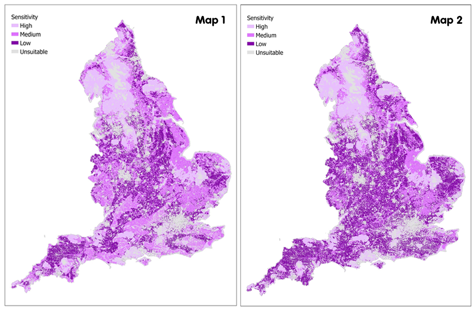
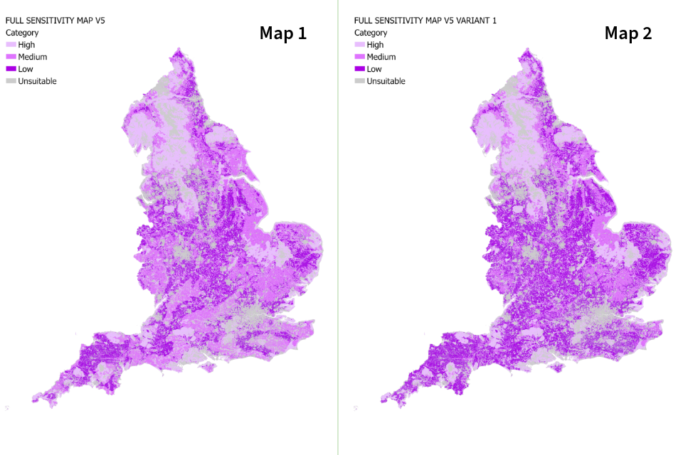
Map 1 and map 2: these maps of England showshowing the different levels of sensitivity by coloured shading. The darkest shading is 'low sensitivity' and the lightest is 'unsuitable' © Crown copyright'unsuitable'.
Map 3: England woodland creation full sensitivity map version 4.05.0 variant 22.
Map 4: England woodland creation full sensitivity map version 4.05.0 variant 33.
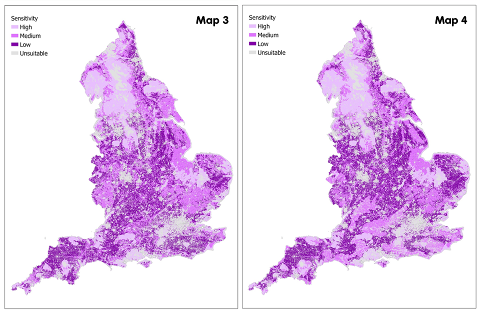
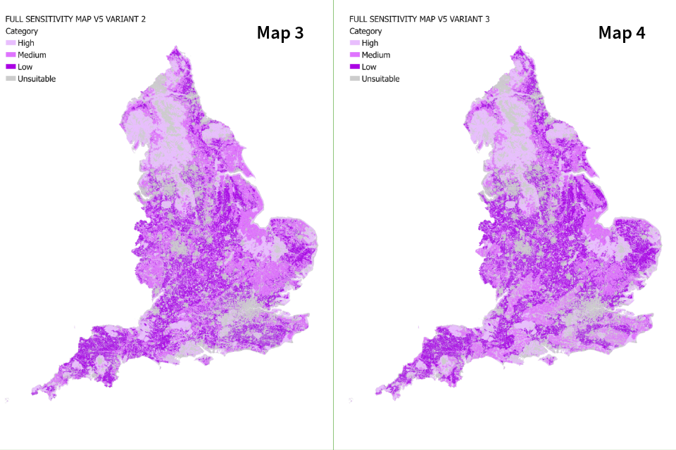
Map 3 and map 4: these maps of England showshowing the different levels of sensitivity by coloured shading. The darkest shading is 'low sensitivity' and the lightest is 'unsuitable' © Crown copyright'unsuitable'.
Map 5: England woodland creation low sensitivity map version 4.05.0.
Map 6: England woodland creation low sensitivity map version 4.05.0 variant 11.
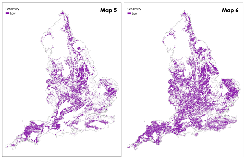
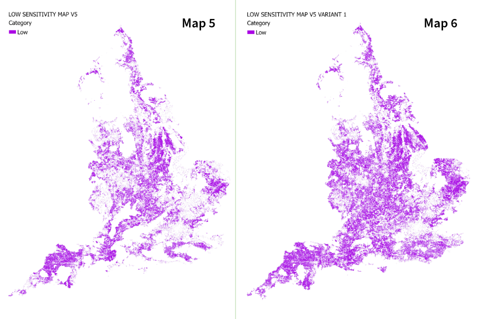
Map 5 and map 6: thesemaps 2of mapsEngland showshowing areas of low sensitivity in England by coloured shading. Map 6 (variant 1) shows slightly more low sensitivity areas © Crown copyrightareas.
Map 7: England woodland creation low sensitivity map version 4.05.0 variant 22.
Map 8: England woodland creation low sensitivity map version 4.05.0 variant 33.
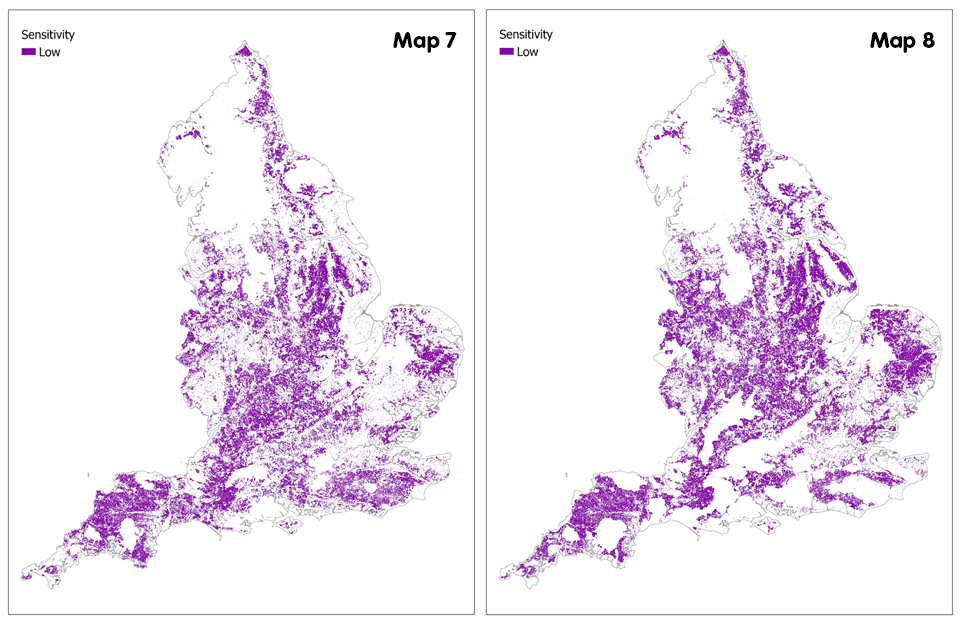
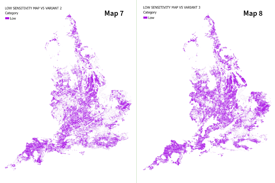
Map 7 and map 8: thesemaps 2of mapsEngland showshowing areas of low sensitivity in England by coloured shading © Crown copyrightshading.
FurtherContact us and further information
For further information on any of these woodland creation sensitivity map geospatial data layers you can contact contact:
evidence@forestrycommission.gov.uk.
Version
Previous 4.0sensitivity representsmap theversions
Version most up to date mapping of known sensitivities to woodland creation. You can also view this guide in PDF format:4.0:

YouVersion can read the
Published
Request 16an Augustaccessible 2023format.
Last
Updatedscreenthereader)guideandtoneedreflecta version4.0ourthissensitivitydocumentmapsinforawoodlandmorecreation.accessibleThisformat,versionpleaserepresentsemailthegrnationalteam@forestrycommission.gov.uk.mostPleaseuptelltousdatewhatmappingformatofyouknownneed.sensitivitiesIttowillwoodlandhelpcreation.Firstyoupublished.